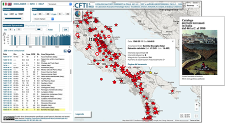
 A study has recently been published on the Catalog of Strong Earthquakes, the CFTI5Med, an easy-to-consult collection where it is possible to visualize the seismic events that occurred in the Italian area between 461 BC and 1997 and those of the Mediterranean area, between 760 BC and 1500. Italy boasts a catalog like few others, this is because historical seismology in our country rests on a long tradition. This allows us to know in detail the effects of the great events of history. Why is it so important? Gianluca Valensise, Research Director of INGV, has revealed to us the secrets kept by past earthquakes.
When do the first sources on earthquakes date back to Italy?
On the Italian territory some particularly sensitive people understood the importance of handing down to posterity the effects of seismic events already between the 1901th and 250th centuries, with the development of inhabited centres. Even the institutions in that period began to produce information and subsequently, in 1117, Mario Baratta compiled a catalog which represented the starting point for future collections: he listed as many as XNUMX Italian seismic centers defining the location of historical earthquakes with accuracy. Few in the world have a collection like ours and by analyzing these detailed descriptions we can understand the earthquakes of the past as if they were recent: this is the case of the strong earthquake that occurred in XNUMX in the province of Verona, reconstructed nine centuries later thanks to data on 'intensity.
Where did the need to draw up a catalog of strong earthquakes in Italy come from?
It was born from the need to integrate such information assets with geophysical and territorial data, in the light of an accurate geographical context. The availability of Geographic Information Systems since the 1995s has made it possible to implement new forms of cataloging and representing data on earthquakes. Thus it was that in XNUMX the first version of the Catalog of Strong Earthquakes in Italy was released, edited by the then National Institute of Geophysics and Environmental Geophysical History, a company specialized in the research and systematization of past adverse events. The catalog constituted a precise repertoire of the territorial, social and economic impacts of earthquakes, initially of intensity greater than the eighth degree of the Mercalli scale. The scale was lowered in subsequent versions which also extended the pertinent area to the entire Mediterranean basin. The result was a substantial computerized database, managed through a web system - GIS.
 What's new in the latest version?
The CFTI5Med presents many new features, in addition to updating the data relating to numerous earthquakes. More than 2.300 descriptions of the environmental effects of the major events have been georeferenced and reprocessed and more than 23.000 testimonials can be downloaded by users in "pdf" format, in the form of scans or transcripts. The possibility of representing seismic events and their effects within the GIS (Geographical Information System) was also implemented, together with other information levels containing geological maps, seismogenic faults and instrumental seismological data, to name but a few.
Why is the historical memory of earthquakes so important?
Because it is thanks to it that it has been possible to arrive at advanced forms of cataloging such as the CFTI5Med, a formidable container of data that lends itself to various studies. Since the extent of the damage is provided location by location, and therefore the intensity in Mercalli scale, it is possible to carry out automatic computer calculations with objectivity and statistical reproducibility. All this helps us to define important parameters and allows us to build seismic hazard models.
What parameters are these?
The magnitude of the earthquake and its epicenter can be defined as a basic level of knowledge. With the CFTI5Med catalog you can get much more: you can define with a certain approximation the fault that generated the earthquake, its length and where it is oriented. The directivity of the fault is a very important parameter. The earthquake is generated by a fracture that propagates in space. Well, that break has a starting point and an ending point and the shaking in places located in that direction will be stronger than in the opposite side. For example, this is what happened with the Calabro Messina earthquake of 1908 where the rupture began in the southern part of the Strait of Messina, in the Ionian Sea, and proceeded at a speed of two kilometers per second, the typical rupture speed of the faults, to the north. This led to the destruction of Reggio Calabria and Messina. If that earthquake had occurred on the same fault but with an opposite direction, this increase in acceleration would have been discharged in the Ionian Sea and perhaps the cities would not have been totally devastated.
 What else do the events of the past tell?
Knowledge of past events also helps us to discover hidden faults, such as those under the Po Valley. These types of faults do not reach the surface so it is difficult to understand where they are located. Historical earthquakes are very useful in this case because they represent fixed points. For example, the 1570 Ferrara earthquake was generated by a blind fault, which does not reach the surface. However, it is a fixed point that tells us that there is something there. This makes it possible to conduct more in-depth studies, also of the subsoil. Without the historical data that "nails" the earthquake like in 1570 we will still be groping in the dark.
Finally there is the issue of complex earthquakes. In Italy, 70% of earthquakes occur with sequences, examples being the earthquake in the Valle del Belice in 1968 and that in Friuli in 1976 up to the seismic sequence in central Italy in 2016. Despite this, until fifteen years ago approximately, in seismic hazard models the sequences were considered as a single event, i.e. only the largest shock was considered. Understanding the complexity of the sequences allows us, instead, to have a statistical basis on which to reason and to better draw the map of the faults in Italy. The ability to "unpack" a strong earthquake into three faults, as happened with the central-southern Italy earthquake of 1456, has made it possible to identify different sources. Without these data we would run the risk of defining an epicenter which is only an average of distant epicenters and this has no physical meaning.
In conclusion, historical seismology provides crucial data for any seismic hazard and risk analysis, but in the eyes of many it may appear to be a less noble discipline than current instrumental seismology. But the full understanding of seismogenesis can only take place by studying the phenomena from all points of view and, in this, historical seismology offers us a fundamental and irreplaceable contribution.


