

Ri-fotografati, a distanza di mezzo secolo, i territori colpiti dal sisma del 1968 per analizzare l’impatto a lungo termine del terremoto sul paesaggio e sull’ambiente
Ri-fotografare a distanza di anni i territori colpiti da terremoti e sovrapporre le immagini attraverso software specifici per comprendere in maniera chiara e immediata i cambiamenti sul paesaggio, analizzando per via indiretta le conseguenze degli eventi sismici dal punto di vista sociale e ambientale. È quanto è stato fatto con lo studio realizzato dall’Istituto Nazionale di Geofisica e Vulcanologia (INGV) in collaborazione con l’Università degli Studi di Catania e l’Accademia di Belle Arti di Palermo. Lo studio, recentemente pubblicato sulla rivista scientifica ‘Land’ di MDPI, evidenzia come la fotografia possa essere uno strumento utile a scopi sia scientifici che divulgativo-formativi, con l’obiettivo ultimo di favorire nella popolazione la consapevolezza del rischio sismico e di altri rischi naturali.
“Partendo dal corposo patrimonio fotografico d’archivio del quotidiano ‘L’Ora’ di Palermo, custodito presso la Biblioteca Centrale della Regione Siciliana, abbiamo investigato gli effetti sul territorio del terremoto che la notte tra il 14 e il 15 gennaio del 1968 colpì la Valle del Belice, nella Sicilia occidentale”, spiega Mario Mattia, ricercatore dell’INGV e co-autore dello studio. “Attraverso un lavoro di campagna svolto nel 2020, abbiamo ri-fotografato quegli stessi luoghi per rilevare la configurazione territoriale più recente e valutare l’impatto del sisma nel tempo”.
Dopo i disastrosi eventi del 1968, la Valle del Belìce ha dovuto attendere alcuni decenni prima di iniziare a sperimentare i primi segnali di rinascita economica, sociale e culturale. Tuttavia, il lento ma costante spopolamento dell’area ha contribuito ad accentuare la percezione di ‘abbandono’ di un territorio in cui gli interventi di ricostruzione, a distanza di oltre 50 anni dal terremoto, non sono riusciti a colmare il divario con il resto del Paese.
“Il lavoro di ri-fotografia della Valle ci ha consentito delle riflessioni che corroborano quanto si può ancora dedurre dall’osservazione diretta del territorio dal punto di vista, ad esempio, dell’abbandono e della museificazione delle rovine”, prosegue il ricercatore. “Un piano ri-fotografico su un periodo di tempo più ampio rispetto al nostro consentirebbe tuttavia una lettura ancora più accurata dei processi territoriali e culturali di lungo respiro. I 50 anni trascorsi dal 1968, infatti, per quanto interminabili siano stati per le comunità locali, sono un periodo di tempo ancora troppo breve per permettere di leggere efficacemente i cambiamenti in un contesto territoriale che sembra essere rimasto ‘congelato’ nel tempo”.
La ri-fotografia è una tecnica spesso utilizzata in sociologia e geomorfologia poiché è in grado di restituire un’efficace narrazione didascalica dell’evoluzione di fenomeni sociali e naturali. Utilizzare lo strumento fotografico (e ri-fotografico) per parlare di rischi naturali può rappresentare un’opportunità per migliorare la percezione del rischio e la resilienza nella popolazione.
“Nella Valle del Belìce, fino al terremoto del 1968, un rischio sismico stimato basso non aveva indotto alcuna azione di mitigazione del rischio né di gestione dei disastri. Da questo punto di vista, l’impatto di immagini in cui gli effetti del terremoto si sovrappongono a quelle di preesistenti insediamenti urbani può stimolare la riflessione sulla percezione del rischio sismico nelle scuole e negli ambienti pubblici. La ri-fotografia, inoltre, può essere utilizzata a integrazione delle valutazioni per l’identificazione delle aree maggiormente vulnerabili della Valle. Primi fondamentali passi, questi, verso la comprensione del rischio sismico nel Belice e verso l’elaborazione e l’attuazione di correlate strategie di mitigazione”, precisa Mattia.
Concludendo, nelle parole del Prof. Gianni Petino dell’Università di Catania "È all’interno del progetto “Belìce +50” che matura la collaborazione tra l’Istituto Nazionale di Geofisica e Vulcanologia, il Dipartimento di Progettazione e Arti Applicate dell’Accademia di Belle Arti di Palermo e il Dipartimento di Scienze Politiche e Sociali dell’Università di Catania. Tale collaborazione ha già prodotto il primo volume a stampa edito dall’INGV dal titolo “Belìce Punto Zero” e vede adesso la realizzazione di un articolo scientifico sulla prestigiosa rivista Land-MDPI che prosegue il processo di analisi del territorio belicino. Le attività di ricerca hanno, tra gli altri, almeno due ordini di riferimento, uno nella mitigazione del rischio sismico e l’altro nel mantenimento della memoria delle comunità locali per una resilienza trasformativa".
---
BELÌCE VALLEY | Photography to analyze the long-term effects of earthquakes
Half a century later, the areas hit by the 1968 earthquake have been re-photographed to analyze the long-term impact of the earthquake on the landscape and the environment
Re-photographing the territories hit by earthquakes years later and superimposing the images through specific software to understand the changes in the landscape in a clear and immediate way, indirectly analyzing the consequences of seismic events from a social and environmental point of view. This is what has been done with the study carried out by the National Institute of Geophysics and Volcanology (INGV) in collaboration with the University of Catania and the Academy of Fine Arts of Palermo.
The study, recently published in MDPI's scientific journal 'Land', highlights how photography can be a useful tool for both scientific and educational purposes, with the ultimate goal of promoting awareness of seismic risk and other natural risks among the population.
"Starting from the substantial photographic archive of the Palermo newspaper 'L'Ora', kept at the Central Library of the Sicilian Region, we investigated the effects on the territory of the earthquake that hit the Valle del Belice, in western Sicily on the night between 14 and 15 January 1968”, explains Mario Mattia, researcher at INGV and co-author of the study. "Through a campaign work carried out in 2020, we re-photographed those same places to detect the most recent territorial configuration and evaluate the impact of the earthquake over time".
After the disastrous events of 1968, the Belìce Valley had to wait a few decades before starting to experience the first signs of economic, social and cultural rebirth. However, the slow but constant depopulation of the area has contributed to accentuating the perception of 'abandonment' of a territory in which the reconstruction interventions, more than 50 years after the earthquake, have failed to bridge the gap with the rest of the Country.
"The re-photography of the Valley has allowed us some reflections that corroborate what can still be deduced from the direct observation of the territory from the point of view, for example, of the abandonment and museification of the ruins", continues the researcher. “A re-photographic plan over a longer period of time than ours would allow an even more accurate reading of long-term territorial and cultural processes. The 50 years that have passed since 1968, in fact, interminable for local communities, are still too short a period of time to allow us to effectively read the changes in a territorial context that seems to have remained 'frozen' over time".
Re-photography is a technique often used in sociology and geomorphology as it is able to provide an effective didactic narrative of the evolution of social and natural phenomena. Using the photographic (and re-photographic) tool to talk about natural hazards can represent an opportunity to improve the perception of risk and resilience in the population.
“In the Belìce Valley, up to the 1968 earthquake, an estimated low seismic risk had not led to any risk mitigation or disaster management actions. From this point of view, the impact of images in which the effects of the earthquake are superimposed on those of pre-existing urban settlements can stimulate reflection on the perception of seismic hazard in schools and public environments. Furthermore, re-photography can be used to supplement the assessments for the identification of the most vulnerable areas of the Valley. These are the first fundamental steps towards understanding the seismic risk in the Belice area and towards the development and implementation of related mitigation strategies", explains Mattia.
In conclusion, as Prof. Gianni Petino of the University of Catania says: “It is within the "Belìce +50" project that the collaboration between the National Institute of Geophysics and Volcanology, the Department of Design and Applied Arts of the Academy of Fine Arts of Palermo and the Department of Political and Social Sciences of the University of Catania is maturing. This collaboration has already produced the first printed volume published by INGV entitled "Belìce Punto Zero", and now sees the creation of a scientific article in the prestigious journal Land-MDPI that continues the analysis process of the Belicino territory. The research activities have, among others, at least two orders of reference, one in the mitigation of seismic hazard and the other in maintaining the memory of local communities for a transformative resilience".
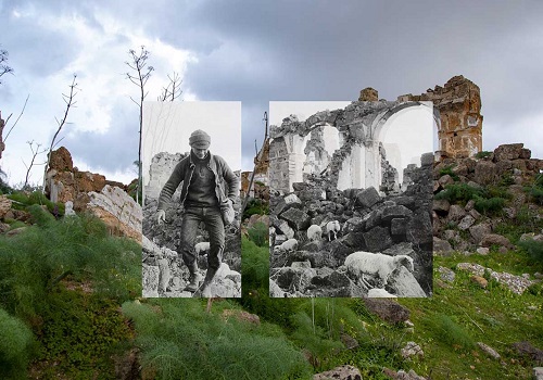
 Foto 1: Rifotografia di uno scorcio del paese di Montevago (Agrigento). La prima fotografia (in bianco e nero) è stata scattata poco dopo il terremoto, la seconda (a colori) è stata scattata nel 2020. Si nota come poco o nulla sia cambiato in 52 anni. - Photo 1: Re-photograph of a glimpse of the town of Montevago (Agrigento). The first photograph (in black and white) was taken shortly after the earthquake, the second (in color) was taken in 2020. It is noticeable how little or nothing has changed in 52 years.
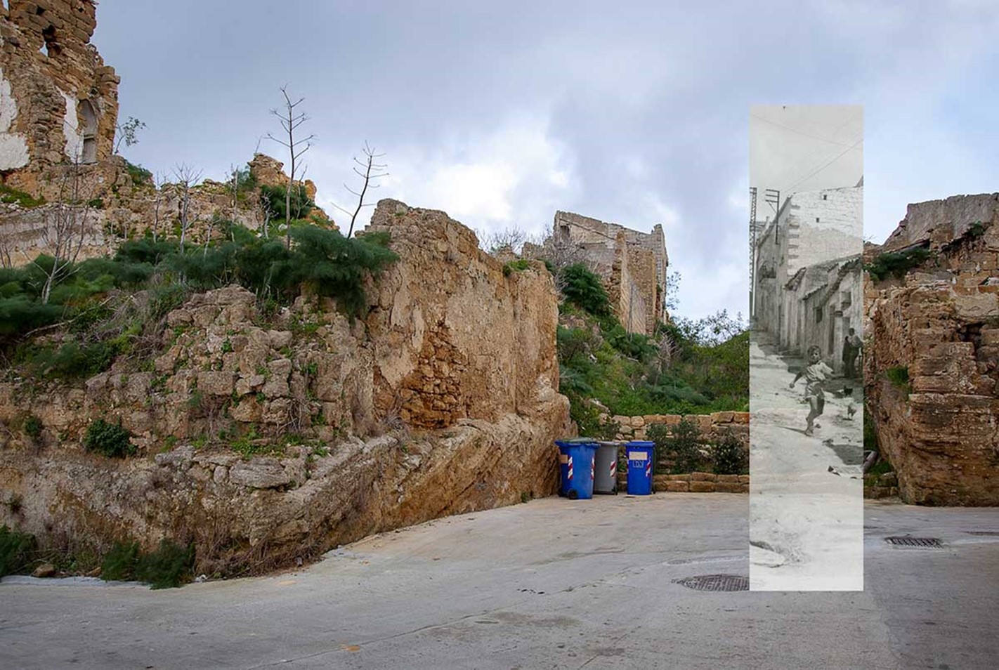 Foto 2: Rifotografia di uno scorcio del paese di Santa Margherita Belice (Agrigento). La prima foto (in bianco e nero) è precedente al terremoto del 1968, la seconda (a colori) è del 2020. - Photo 2: Re-photograph of a glimpse of the town of Santa Margherita Belice (Agrigento). The first photo (in black and white) is from before the 1968 earthquake, the second (in color) is from 2020.
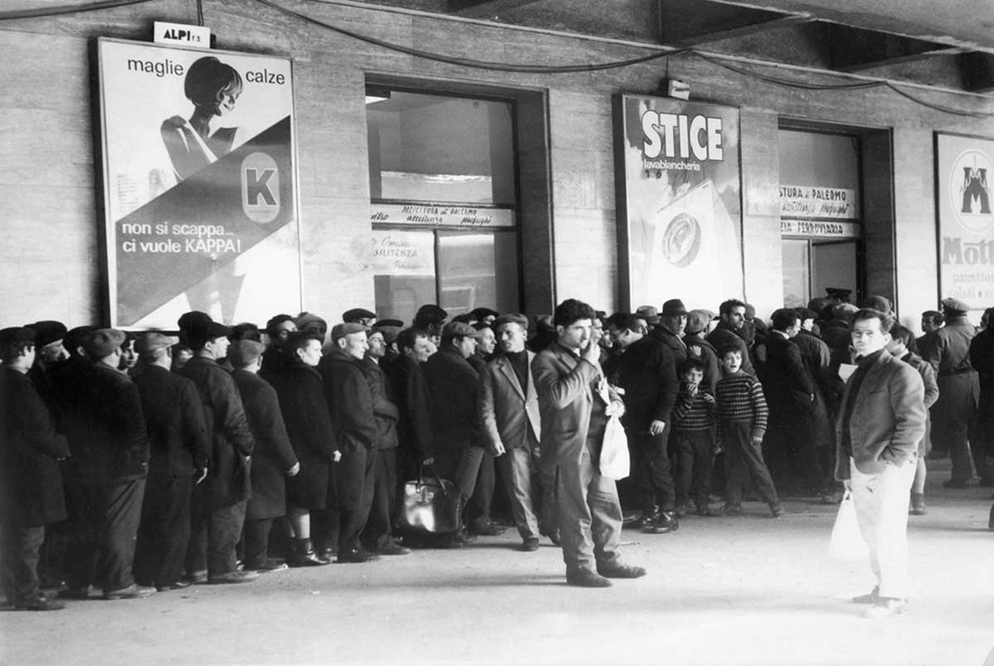 Foto 3: Terremotati in fila in attesa dei treni verso il Nord Italia. Dopo il terremoto lo Stato fornì gratuitamente biglietti ferroviari a tutti i terremotati per raggiungere il Nord, dove questa enorme massa (oltre 50.000 persone) avrebbe rappresentato una forza-lavoro a basso costo e non sindacalizzata. - Photo 3: Earthquake victims lined up waiting for trains to Northern Italy. After the earthquake, the Government provided free train tickets to all earthquake victims to reach the North, where this enormous mass (over 50,000 people) would have represented a low-cost and non-unionized workforce.