

 .
.Con un ampio rinnovamento dei contenuti, una nuova veste grafica e nuove funzionalità, è stata rilasciata la nuova versione del Database of Individual Seismogenic Sources (DISS)
Il , realizzato da un team di ricercatori dell’Istituto Nazionale di Geofisica e Vulcanologia (INGV), è un archivio georeferenziato di faglie sismogenetiche (ovvero potenzialmente capaci di generare terremoti), identificate negli anni attraverso dati e studi geologici, geofisici e storici. È espressamente dedicato ad applicazioni nella valutazione della pericolosità sismica a scala regionale e nazionale, oltre che allo sviluppo di modelli geodinamici.
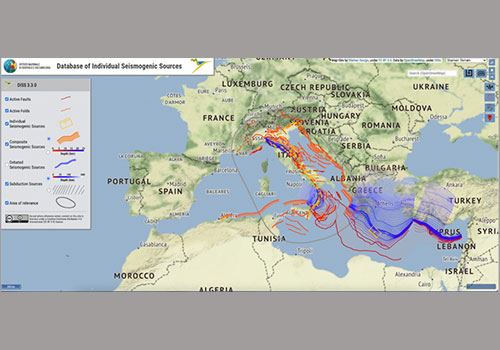
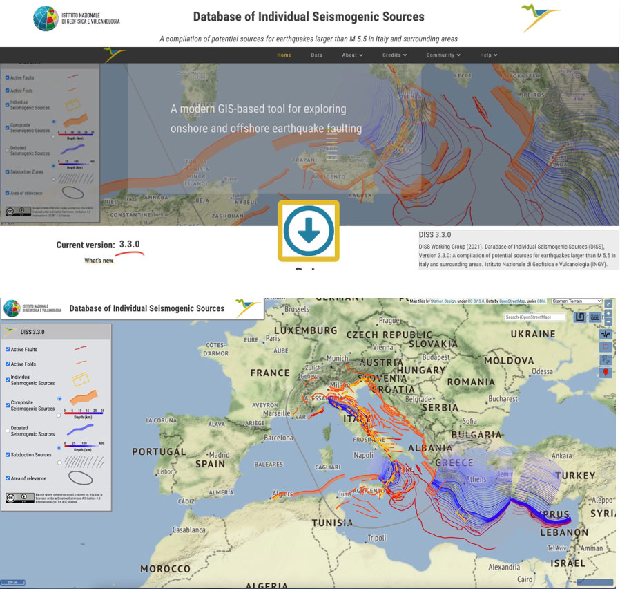
Con i suoi molteplici strumenti di navigazione, la nuova versione 3.3.0 di DISS si presenta totalmente rinnovata. Attraverso la semplice visualizzazione in mappa è possibile “vedere” in tre dimensioni le sorgenti sismogenetiche o, più semplicemente, le faglie che hanno causato o possono causare forti terremoti nel nostro territorio nazionale, in alcune aree adiacenti e in buona parte del Mediterraneo centrale. È inoltre possibile consultare la vasta documentazione che accompagna le sorgenti, ed infine è possibile rappresentare accanto ad esse il contenuto di diverse altre banche-dati, tra cui quelle della sismicità strumentale e storica.
Navigando nelle mappe, oggi è possibile consultare le “sorgenti individuali”, che in genere rappresentano le faglie che hanno causato i forti terremoti del passato; le “sorgenti composite”, ovvero rappresentazioni semplificate di sistemi di faglie estesi che possono includere alcune sorgenti individuali; e le “zone di subduzione”, che propongono una struttura semplificata di questi importanti elementi geodinamici. Sono, infine, visibili anche le “sorgenti dibattute”, cioè quelle faglie attive che una parte della letteratura scientifica propone come potenziali faglie sismogenetiche, ma per le quali non esistono ancora conoscenze sufficientemente complete.
Il Database, partito ormai oltre vent’anni fa nella sua primissima edizione nel 2001, è nato con lo scopo di investigare e sistematizzare le conoscenze sulla sismogenesi del territorio italiano. I successivi sviluppi, dovuti sia al miglioramento delle conoscenze geologico-geofisiche della penisola italiana (a loro volta in gran parte dovuti al verificarsi dei forti terremoti che si sono susseguiti negli anni, dalla sequenza del Molise del 2002 sino a quella del Centro Italia del 2016-2017), sia ai nuovi impieghi nel campo della pericolosità sismica e da tsunami, hanno apportato profonde trasformazioni alla struttura di DISS e alle tipologie di sorgenti in esso contenute.
Per la nuova versione del DISS sono state considerate le più recenti conoscenze sulla subduzione dell'Arco Calabro, è stato completamente rielaborato l’assetto delle sorgenti dell’Appennino centrale in seguito alle novità emerse dalla sequenza del 2016-2017, e sono state riconsiderate numerose aree dell'Adriatico centrale e meridionale, dello Ionio e del Canale di Sicilia. Inoltre, facendo riferimento alle leggi di scala più aggiornate oggi disponibili, è stato applicato un nuovo criterio per la stima del terremoto più forte che le sorgenti sismogenetiche possono generare (Mmax).
I contenuti di questa nuova versione del DISS sono stati già utilizzati nell'ambito del nuovo.
Tutte le versioni di DISS sono in file di vario formato e sono utilizzabili attraverso i servizi web per l’interoperabilità che seguono lo standard dell’. Completa il quadro uno strumento che consente l'interoperabilità tra il DISS e ITHACA, la banca-dati delle faglie attive e capaci curata dall’ISPRA.
La nuova versione del DISS, dunque, contribuisce a ridefinire e dettagliare il modello di sismogenesi alla scala del Mediterraneo centrale, fornendo un moderno strumento di consultazione e indagine, diretta non solo ai ricercatori ma anche ai professionisti impegnati nella progettazione di opere di varia natura e nella microzonazione del territorio, oltre che ai tecnici e ai decisori istituzionali preposti alla prevenzione e gestione dei rischi.
#DISS #SorgenteSismogenetica #FagliaAttiva #subduzione #ESHM20
A NEW WEBSITE FOR THE SEISMOGENIC SOURCES DATABASE
With extensive content renewal, new graphics and new features, the new version of the Database of Individual Seismogenic Sources (DISS) is online
The , created by a team of researchers from the Istituto Nazionale di Geofisica e Vulcanologia (INGV), is a georeferenced archive of seismogenic faults (i.e. potentially capable of generating earthquakes), identified over the years through geological, geophysical and historical data and studies. It is expressly dedicated to applications of seismic hazard assessment on a regional and national scale, as well as to the development of geodynamic models.
With its multiple navigation tools, the new 3.3.0 version of DISS is totally renewed. Through the simple visualization on map, it is possible to “see” in three dimensions the seismogenic sources, or more simply the faults which caused or can cause strong earthquakes in Italy's National territory, in some adjacent areas and in a large part of the central Mediterranean. It is also possible to browse through the extensive documentation that accompanies the sources, and it is also possible to represent the content of various other databases alongside the sources, including those of instrumental and historical seismicity.
Browsing the maps, today it is possible to consult the “individual sources”, which generally represent the faults that caused strong earthquakes of the past; the "composite sources", i.e., simplified representations of extended fault systems that may include a number of individual sources; and the “subduction zones”, which offer a simplified structure of these prominent geodynamic elements. Finally, the "debated sources" are also visible, i.e. those active faults that some of the scientific literature proposes as potential seismogenic faults, but for which sufficient knowledge does not yet exist.
The Database, which started over twenty years ago in its very first edition in 2001, was born with the aim of investigating and systematizing knowledge on the seismogenesis of the Italian territory. The subsequent developments, due both to the improvement of the geological-geophysical knowledge of the Italian peninsula (in turn largely due to the occurrence of the strong earthquakes that have occurred over the years, from the Molise sequence in 2002 to that of Central Italy in 2016-2017), and to the new applications in the field of seismic and tsunami hazards, have brought about profound transformations to the structure of DISS and to the types of sources it contains.
For the new version of the DISS, the most recent knowledge on the subduction of the Calabrian Arc has been considered, and the arrangement of the sources of the central Apennines has been completely reworked following the innovations that emerged from the 2016-2017 sequence, as numerous areas of the central and southern Adriatic Sea, the Ionian Sea and the Strait of Sicily have been reconsidered. Furthermore, referring to the most up-to-date scaling laws, a new criterion for estimating the strongest earthquake that seismogenic sources can generate (Mmax) was applied.
The contents of this new version of the DISS have already been used in the context of the new .
All versions of DISS can be in various file formats and can be accessed through the web services for interoperability that adhere to the standard. The features include a tool that allows interoperability between DISS and ITHACA, the database of active and capable faults maintained by ISPRA.
The new version of the DISS, therefore, contributes to redefine and outline the seismogenic model at the scale of the central Mediterranean, providing a modern tool for consultation and direct investigation not only to researchers but also to practitioners involved in designing infrastructures of various kinds and in the microzonation of the territory, as well as stakeholder and institutional decision-makers in charge of risk prevention and management.
#DISS #SeismogenicSource #faults # subduction #ESHM20