

L’onda di pressione atmosferica generata dall’eruzione avvenuta nel Pacifico nel gennaio 2022 ha investito anche l’area del Mediterraneo meridionale ed è stata registrata dalle reti di monitoraggio dell’INGV
La violenta eruzione del vulcano Hunga Tonga-Hunga Ha'apai verificatasi il 15 gennaio 2022 nel bel mezzo dell’Oceano Pacifico, tra la Nuova Zelanda e le isole Fiji, ha generato disturbi atmosferici su scala globale osservati anche nell’atmosfera del Mediterraneo grazie alle stazioni barometriche e infrasoniche dell’Istituto Nazionale di Geofisica e Vulcanologia (INGV) installate sui vulcani attivi italiani.
È quanto emerge dallo studio realizzato da un team multidisciplinare di ricercatori dell’INGV, dell’Università degli Studi di Catania e del Servizio Informativo Agrometeorologico Siciliano (SIAS), recentemente pubblicato sulla rivista internazionale ‘Atmosphere’ di MDPI.
“L’eruzione cataclismica dell’Hunga Tonga-Hunga Ha'apai del 2022 ha innescato un aumento enorme di elettroni totali nella ionosfera e un’onda di pressione atmosferica che ha viaggiato per migliaia di chilometri nella troposfera, provocando vibrazioni del suolo e perturbazioni secondarie”, spiega Alessandro Bonforte, ricercatore dell’INGV e co-autore dello studio. “Analizzando i dati barometrici raccolti a terra abbiamo evidenziato come queste ‘onde’ di pressione sono state riflesse e diffratte dalla superficie terrestre, creando una complessa dinamica spazio-temporale tra le perturbazioni atmosferiche che hanno viaggiato sulla Sicilia, guidate dall’interferenza tra i diversi fronti d’onda”.
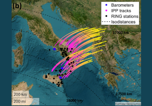
I dati che hanno permesso di studiare i disturbi atmosferici generati dall’eruzione sono stati raccolti da numerose strumentazioni dell’INGV: le stazioni barometriche e infrasoniche sui vulcani attivi in Italia, da Catania ai Campi Flegrei in Campania; le reti , le ionosonde installate a Gibilmanna (PA) per l'analisi delle perturbazioni nella ionosfera; la rete dedicata al monitoraggio in continuo delle deformazioni del suolo attraverso il sistema GNSS; la rete per il monitoraggio del flusso di anidride carbonica (CO2) sull’isola di Vulcano. Inoltre, per lo studio sono stati acquisiti anche i dati rilevati dalla rete della Regione Siciliana dedicata allo studio dell’interazione tra orografia e onde di pressione.
L’Hunga Tonga-Hunga Ha'apai è un vulcano storicamente noto per aver prodotto, circa 900 anni fa, una serie di grandi eruzioni seguite da numerosi eventi meno energetici, il penultimo dei quali aveva formato una nuova isola tra il 2014 e il 2015. L’eruzione più recente, quella del 2022, si è affermata come la più violenta degli ultimi 138 anni, paragonabile a quelle del Krakatau (1883) e del Pinatubo (1991).
“Studi recenti avevano già evidenziato come fenomeni naturali estremi quali terremoti, tsunami ed eruzioni vulcaniche possano innescare delle onde acustiche e gravitazionali che si propagano verso l’alto nell’atmosfera e nella ionosfera: le misure raccolte con il nostro lavoro hanno confermato il passaggio nell’area del Mediterraneo meridionale della perturbazione atmosferica generata dall’eruzione (propagatasi a una velocità di circa 310 m/s ), identificando gli effetti prodotti dalla topografia terrestre sull'onda di pressione e la relazione tra l'onda acustica in troposfera e la perturbazione indotta sul plasma ionosferico”, conclude Paolo Madonia, ricercatore dell’INGV e co-autore dello studio.
I due passaggi dell'onda d'urto sul Mediterraneo sono stati registrati da una rete di sensori multiparametrici sondando l'atmosfera a diverse altezze. I dati acquisiti possono essere interpretati come uno shock test in grado di fornire informazioni sulla risposta atmosferica, a scala terrestre, a effetti di pressione di breve durata come quelli innescati da esplosioni vulcaniche. Questi eventi sono tipici di condizioni atmosferiche turbolente, sempre più frequenti a causa dell'accelerazione dei fenomeni meteorologici causati dai cambiamenti climatici.
Pertanto, avere reti di acquisizione operanti ad alte frequenze e a diverse quote, come quelle sviluppate per la sorveglianza dei vulcani attivi, in grado di rilevare fenomeni di breve durata (come le esplosioni vulcaniche), ha consentito di poter acquisire dati altamente affidabili. Al contrario, invece, delle normali reti meteorologiche, composte da stazioni distanti tra loro decine di chilometri e che acquisiscono dati a bassa frequenza, risultando inadeguate per la rilevazione di segnali come quelli generati dall'esplosione del vulcano Hunga.
Citazione dello studio: Madonia, P.; Bonaccorso, A.; Bonforte, A.; Buonocunto, C.; Cannata, A.; Carleo, L.; Cesaroni, C.; Currenti, G.; De Gregorio, S.; Di Lieto, B.; Guerra, M.; Orazi, M.; Pasotti, L.; Peluso, R.; Pezzopane, M.; Restivo, V.; Romano, P.; Sciotto, M.; Spogli, L. Propagation of Perturbations in the Lower and Upper Atmosphere over the Central Mediterranean, Driven by the 15 January 2022 Hunga Tonga-Hunga Ha’apai Volcano Explosion. Atmosphere 2023, 14, 65.
Link utili:
Progetto INGV TROPOMAG
Rete INGV RING
Servizio Informativo Agrometeorologico Siciliano (SIAS)
Università degli Studi di Catania
---
HUNGA TONGA-HUNGA HA'APAI | The effects of the great eruption of 2022 observed over the Mediterranean
The atmospheric pressure wave generated by the eruption that took place in the Pacific Ocean in January 2022 also affected the southern Mediterranean area and it was recorded
by the INGV monitoring networks
The violent eruption of the Hunga Tonga-Hunga Ha'apai volcano, which occurred on 15 January 2022 in the middle of the Pacific Ocean, between New Zealand and the Fiji Islands, generated atmospheric disturbances on a global scale, which were also observed over the Mediterranean, thanks to the barometric and infrasonic sensors of the National Institute of Geophysics and Volcanology (INGV) installed on Italian active volcanoes.
This is what emerges from the study , carried out by a multidisciplinary team of researchers from INGV, the University of Catania and the Sicilian Agrometeorological Information Service (SIAS), recently published in the international journal “Atmosphere” from MDPI.
“The 2022 Hunga Tonga-Hunga Ha'apai’s cataclysmic eruption triggered a massive increase in total electrons in the ionosphere, and an atmospheric pressure wave that traveled thousands of kilometers in the troposphere, causing ground vibrations and secondary perturbations”, explains Alessandro Bonforte, INGV researcher and co-author of the study. “By analyzing the barometric data collected on the ground, we have highlighted how these pressure waves have been reflected and diffracted by the Earth’s surface, creating an interference between the different wave fronts, and generating a complex baric perturbation that traveled over Sicily.”.
The data that made it possible to study the atmospheric disturbances generated by the eruption were collected by several INGV instruments: the barometric and infrasonic stations on active volcanoes in Italy, from Catania to Campi Flegrei in Campania; the networks, the ionosonde installed in Gibilmanna (PA) for the analysis of perturbations in the ionosphere; the network dedicated to the continuous monitoring of ground deformations through the GNSS system; the network for monitoring the flow of carbon dioxide (CO2) on the island of Vulcano. Furthermore, data collected by the network of the Sicilian Region dedicated to the study of the interaction between orography and pressure waves were also acquired for the study.
Hunga Tonga-Hunga Ha'apai is a volcano historically known to have produced, about 900 years ago, a series of large eruptions followed by numerous less energetic events, the penultimate of which had formed a new island between 2014 and 2015. The most recent eruption, that of 2022, has established itself as the most violent in the last 138 years, comparable to those of Krakatau (1883) and Pinatubo (1991).
“Recent studies had already highlighted how extreme natural phenomena, such as earthquakes, tsunamis and volcanic eruptions can trigger acoustic and gravitational waves that propagate in the atmosphere up to the ionosphere: the measurements collected with our work have confirmed the passage, in the southern Mediterranean area, of the atmospheric perturbation generated by the eruption (propagating at a speed of about 310 m/s), identifying the effects produced by the land topography on the pressure wave and the relationship between the acoustic wave in the troposphere and the perturbation induced on the ionospheric plasma”, concludes Paolo Madonia, INGV researcher and co-author of the study.
The two passages of the shock wave over the Mediterranean were recorded by a network of multi-parameter sensors probing the atmosphere at different heights. The acquired data can be interpreted as a shock test capable of providing information on the atmospheric response, at the Earth scale, to short-term pressure effects such as those triggered by volcanic explosions. These events are typical of turbulent atmospheric conditions, increasingly frequent due to the acceleration of meteorological phenomena caused by climate change.
Therefore, acquisition networks operating at high frequencies and at different altitudes, such as those developed for the surveillance of active volcanoes, capable of detecting short-term phenomena (such as volcanic explosions), has made it possible to acquire highly reliable data. On the other hand, this is the opposite of normal meteorological networks, made up of stations tens of kilometers away from each other and which acquire low-frequency data, making them inadequate for detecting signals such as those generated by the explosion of the Hunga volcano.
Study citation: Madonia, P.; Bonaccorso, A.; Bonforte, A.; Buonocunto, C.; Cannata, A.; Carleo, L.; Cesaroni, C.; Currenti, G.; De Gregorio, S.; Di Lieto, B.; Guerra, M.; Orazi, M.; Pasotti, L.; Peluso, R.; Pezzopane, M.; Restivo, V.; Romano, P.; Sciotto, M.; Spogli, L. Propagation of Perturbations in the Lower and Upper Atmosphere over the Central Mediterranean, Driven by the 15 January 2022 Hunga Tonga-Hunga Ha’apai Volcano Explosion. Atmosphere 2023, 14, 65.
Link:
Project INGV TROPOMAG
Network INGV RING
Servizio Informativo Agrometeorologico Siciliano (SIAS)
Università degli Studi di Catania
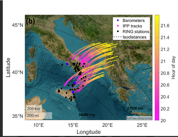
Immagine 1 - Tracce Ionospheric Pierce Point (IPP) dalle diverse stazioni RING, in cui i colori rappresentano l'ora del giorno. Le curve nere tratteggiate rappresentano i punti con la stessa distanza dal vulcano Hunga.
I punti neri e blu rappresentano, rispettivamente, la posizione dei ricevitori GNSS e dei barometri.
Tracks Ionospheric Pierce Point (IPP) from the different RING stations: the colors represent the time of day. The dashed black curves represent points with the same distance from the Hunga volcano.
Black and blue dots represent the positions of the GNSS receivers and barometers, respectively.
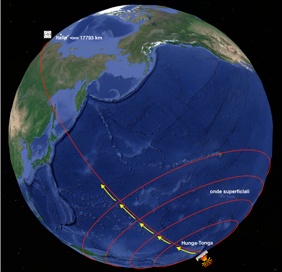
Immagine 2 - Fonte:
Immagine 3 - Fonte: .