
Realizzata la rappresentazione digitale della nuova morfologia del vulcano Cumbre Vieja a seguito dell’eruzione avvenuta tra settembre e dicembre 2021 sull’isola di La Palma
L’eruzione ha avuto un impatto enorme per l’ecosistema dell’isola e la realizzazione del modello digitale dopo soli pochi mesi dalla fine degli eventi, è un risultato particolarmente utile anche per la ricostruzione dell’area.
Nello studio “High-resolution Digital Surface Model of the 2021 eruption deposit of Cumbre Vieja volcano, La Palma, Spain”, recentemente pubblicato sulla rivista ‘Scientific Data’ di Nature, i ricercatori dell’Istituto Nazionale di Geofisica e Vulcanologia (INGV), in collaborazione con l’Instituto Volcanológico de Canarias (INVOLCAN), hanno presentato il modello digitale della superficie e condiviso i risultati principali dello studio dell’eruzione. I dati sono stati ricavati da rilievi aerofotogrammetrici effettuati durante l’eruzione e al termine di essa con i droni e grazie alle tecniche “Structure from Motion”. Il team di ricercatori INGV, specializzato anche nelle riprese in aree a rischio vulcanico, è intervenuto nell’ambito della collaborazione scientifica internazionale su richiesta e in coordinamento con i colleghi di INVOLCAN.
L’eruzione ha provocato danni rilevanti a diversi centri abitati dell’isola di La Palma e ha forzato l'evacuazione di oltre seimila persone dalle loro case.
Riccardo Civico, ricercatore dell’INGV e primo autore dello studio, spiega “Più di 200 milioni di metri cubi di deposito, prevalentemente lave, hanno causato profondi cambiamenti morfologici nella porzione occidentale dell'isola, interessando sia l’ambiente naturale che antropico per un’estensione di decine di chilometri quadrati, come testimoniato dal modello digitale presentato in questa pubblicazione.”
Aggiunge Luca D’Auria, Direttore dell’area di vigilanza vulcanica dell’Instituto Volcanológico de Canarias (INVOLCAN): “Le lave prodotte dall’eruzione, che in alcuni punti hanno superato i 60 metri di spessore, hanno distrutto oltre 1600 edifici, più di 200 di ettari di bananeti, principale risorsa economica dell’isola oltre al turismo, e importanti infrastrutture come strade, linee elettriche, acquedotti, arrivando fino all’oceano e modificando la linea di costa. Questo lavoro ci fornisce un importante contributo per definire il quadro dell'eruzione e costituisce un utile strumento per la pianificazione degli interventi di recupero dell’area urbana invasa dai prodotti dell’attività vulcanica”.
Conclude Piergiorgio Scarlato, coordinatore delle attività dell’INGV a supporto di INVOLCAN sull’isola di La Palma nel corso della crisi vulcanica, “I droni si confermano strumenti determinanti per rilevare in sicurezza le aree interessate da eventi naturali non altrimenti raggiungibili, in particolare nel corso di una eruzione vulcanica. Durante gli oltre 800 km di sorvoli effettuati dai nostri droni sono state raccolte più di 12000 immagini aeree ad alta risoluzione e georeferenziate, dandoci la possibilità di costruire una mappatura di grande dettaglio del campo lavico e del nuovo edificio vulcanico formatosi. Sono stati quindi ricavati il volume totale e il tasso eruttivo dei prodotti vulcanici emessi dal vulcano tra settembre e dicembre 2021. Quest’ultimo nei primi giorni di eruzione ha avuto una media di circa 60 metri cubi al secondo”.
Studio: Civico et al., 2022, High-resolution Digital Surface Model of the 2021 eruption deposit of Cumbre Vieja volcano, La Palma, Spain”, Scientific Data, doi:10.1038/s41597-022-01551-8
Link:
Primi dettagli dello studio sul Blog INGVvulcani
Voli dei droni sul Cumbre Vieja sul canale YouTube INGVvulcani:
---
CUMBRE VIEJA | Digital surface model of the 2021 eruption in the Canary Islands published
The digital representation of the new morphology of the Cumbre Vieja volcano has been created after the eruption that took place between September and December 2021
The eruption had a huge impact on the ecosystem of the island and the publication of the digital surface model after only a few months from the end of the events, is a particularly useful result also for the management of the area.
In the study "High-resolution Digital Surface Model of the 2021 eruption deposit of Cumbre Vieja volcano, La Palma, Spain", recently published in the journal 'Scientific Data' of Nature, the researchers of the National Institute of Geophysics and Volcanology (INGV), in collaboration with the Instituto Volcanológico de Canarias (INVOLCAN), presented the digital surface model and shared the main results of the study. The data were obtained from aerial photogrammetric surveys carried out using drones both during and after the eruption and using the "Structure from Motion" technique. The INGV team of researchers, also specialized in acquiring data in active volcanic areas, intervened in the context of international scientific collaboration on request and in coordination with INVOLCAN colleagues.
The eruption caused significant damage to several towns on the island of La Palma and forced the evacuation of over six thousand people from their homes.
Riccardo Civico, INGV researcher and first author of the study, explains "More than 200 million cubic meters of deposit, mainly lava, have caused profound morphological changes in the western part of the island, affecting both the natural and the anthropogenic environment for an extent of tens of square kilometers, as evidenced by the digital model in this publication”.
Luca D'Auria, Director of the Volcanic Surveillance Area of the Instituto Volcanológico de Canarias (INVOLCAN) adds: “The lava produced by the eruption, which in some points exceeded 60 meters in thickness, destroyed over 1600 buildings, 200 hectares of banana groves, the main economic resource of the island in addition to tourism, and important infrastructures such as roads, power lines, aqueducts. It reached the ocean and changed the coastline. This study provides us with an important contribution to define the picture of the eruption and is a useful tool for planning the recovery interventions of the urban area invaded by the products of volcanic activity".
Piergiorgio Scarlato, coordinator of the INGV activities in support of INVOLCAN on the island of La Palma during the volcanic crisis, concludes, "Drones are confirmed as decisive tools for safely detecting areas affected by natural events that cannot otherwise be reached, in particular during a volcanic eruption. More than 12,000 high-resolution and geo-referenced aerial images have been collected by making over 800 km of flyovers with our drones. This allowed us to build a highly detailed mapping of the lava field and of the new volcanic building that was forming. In the end, we calculated the total volume and the eruptive rate of the volcanic products emitted by the volcano between September and December 2021. In the first days of the eruption it had an average of about 60 cubic meters per second”.
Study: Civico et al., 2022, High-resolution Digital Surface Model of the 2021 eruption deposit of Cumbre Vieja volcano, La Palma, Spain”, Scientific Data, doi:10.1038/s41597-022-01551-8
Link:
First details of the study on the INGVvulcani Blog
Drone flights over the Cumbre Vieja on the INGV YouTube channel:
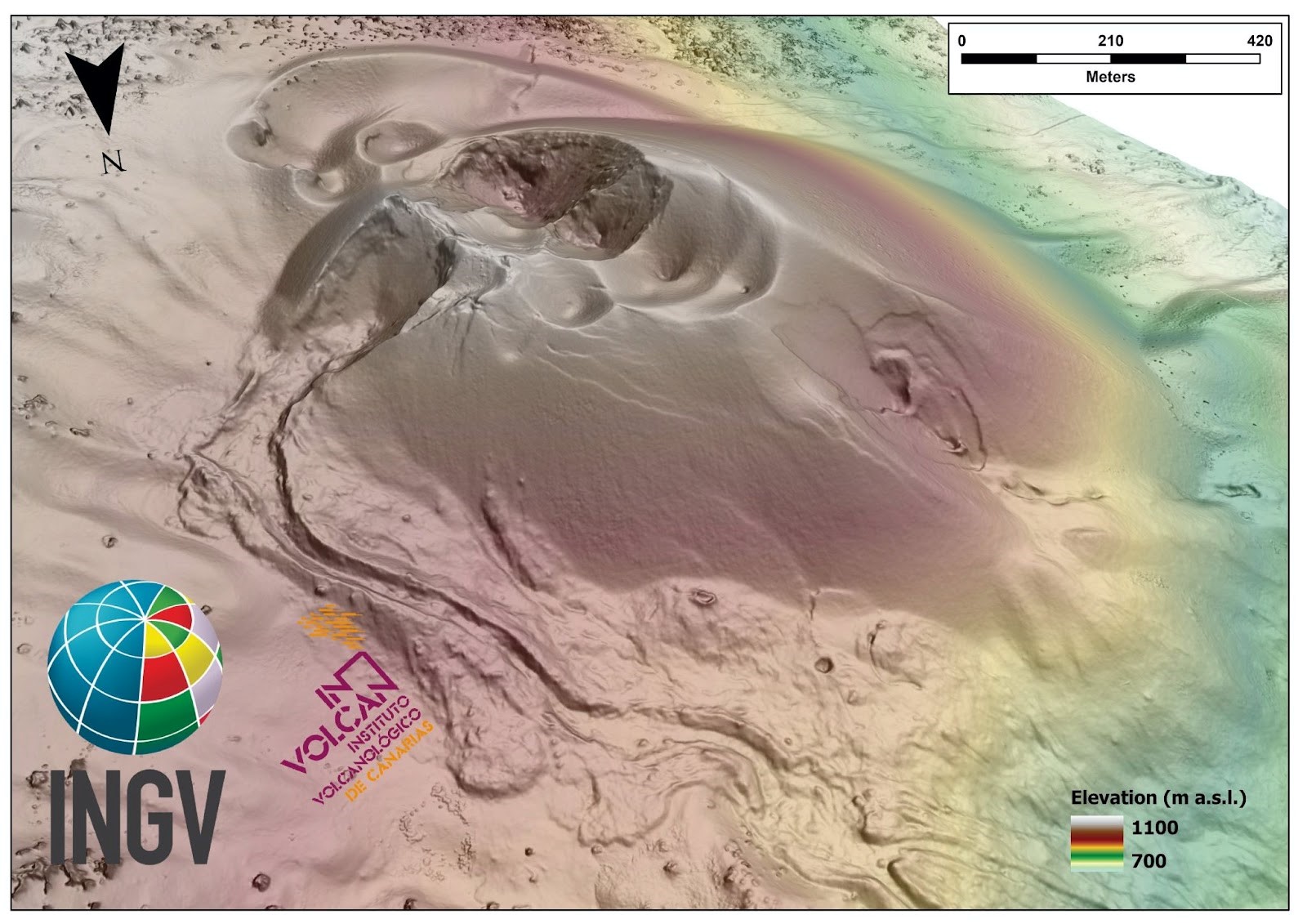
Immagine 1 - Modello digitale della superficie del cono eruttivo formatosi nel corso dell’eruzione del vulcano Cumbre Vieja (19 settembre - 13 dicembre 2021).
Image 1 - Digital surface model of the eruptive cone formed during the eruption of the Cumbre Vieja volcano (19 September - 13 December 2021).
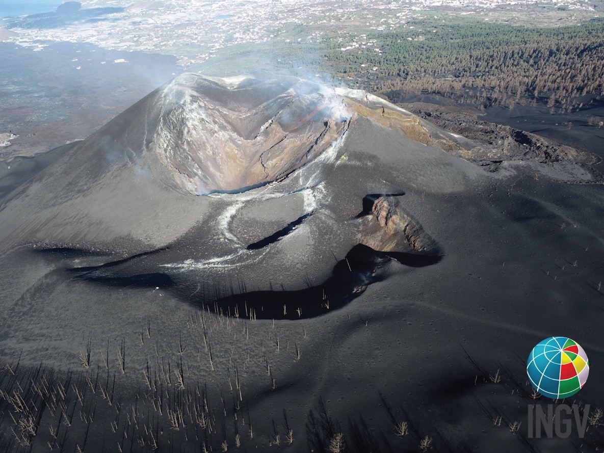
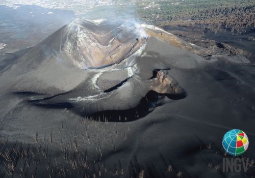
Immagine 2 - Veduta aerea del cono eruttivo formatosi nel corso dell’eruzione del vulcano Cumbre Vieja (19 settembre - 13 dicembre 2021).
Image 2 - Aerial view of the eruptive cone formed during the eruption of the Cumbre Vieja volcano (19 September - 13 December 2021).
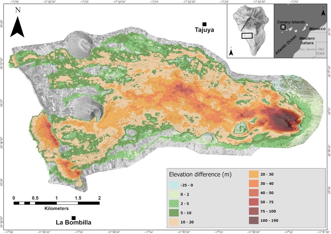
Immagine 3 - Differenze di elevazione per il periodo 2015 - Gennaio 2022 (pre- e post- eruzione 2021 del vulcano Cumbre Vieja).
Image 3 - Elevation differences for the period 2015 - January 2022 (pre- and post-eruption 2021 of the Cumbre Vieja volcano).
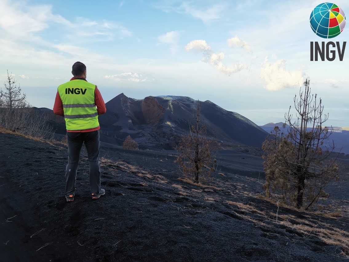
Immagine 4 - Ricercatori INGV impegnati nei rilievi aerofotogrammetrici nella zona interessata dell’eruzione del vulcano Cumbre Vieja (19 settembre - 13 dicembre 2021).
Image 4 - INGV researchers engaged in aerial photogrammetric surveys in the area of the eruption of the Cumbre Vieja volcano (19 September - 13 December 2021).
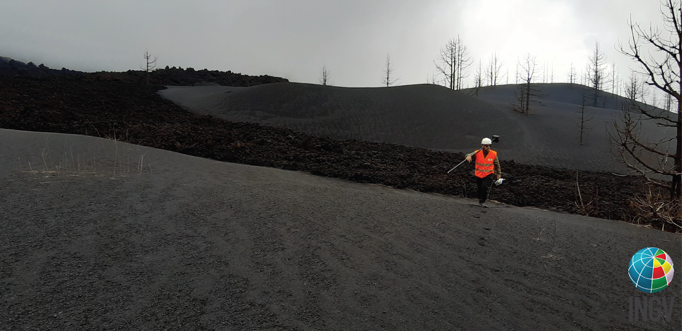
Immagine 5 - Ricercatori INGV impegnato nei rilievi aerofotogrammetrici nella zona interessata dell’eruzione del vulcano Cumbre Vieja (19 settembre - 13 dicembre 2021).
Image 5 - INGV researchers engaged in aerial photogrammetric surveys in the area of the eruption of the Cumbre Vieja volcano (19 September - 13 December 2021).