

Anche nel 2020 si conferma la media di 45 terremoti al giorno localizzati dalle Sale di Sorveglianza operative h24 dell’Istituto: circa 1 ogni 30 minuti.
Nello “Speciale 2020” del Blog INGV Terremoti, si può “navigare” tra gli eventi sismici con mappe interattive, story map e infografiche.
Nel corso del 2020 la Rete Sismica Nazionale dell’Istituto Nazionale di Geofisica e Vulcanologia (INGV) ha localizzato 16.597 terremoti sul territorio italiano e nelle zone limitrofe. Una media di circa 45 terremoti al giorno con un intervallo di un evento ogni mezz’ora circa.
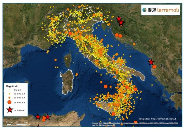
“Nella mappa che abbiamo realizzato quest’anno si evidenzia che anche nel 2020 i più forti terremoti sono stati localizzati al di fuori del territorio italiano. Gli eventi sismici di magnitudo pari o superiore a 5.0 sono avvenuti in Albania, in Algeria e in Croazia, durante la sequenza sismica di fine dicembre con il forte terremoto di magnitudo Mw 6.3 del 29 dicembre, nei pressi della città di Petrinja”, afferma Alessandro Amato, sismologo dell’INGV, che sottolinea “Il numero di terremoti localizzati in Italia nel 2020 è molto simile a quello del 2019, un numero inferiore se lo si confronta con i terremoti del 2016 e 2017 caratterizzati dalla sequenza sismica in Italia Centrale, iniziata il 24 agosto 2016".
Il primo terremoto del 2020 si è verificato il 1° gennaio 2020 a Sefro (MC) solo un minuto e mezzo dopo lo scoccare della mezzanotte e l’ultimo, invece, il 31 dicembre 2020 alle ore 23:41 a Ragalna (CT), entrambi con una magnitudo inferiore a 2.0.
Come sempre, invece, la Sardegna si conferma la regione con il minor numero di terremoti. Contando anche le aree marine intorno all’isola, nei 366 giorni del 2020 se ne sono registrati solo 4.
“Quasi il 90% dei terremoti localizzati in Italia nel 2020 ha avuto magnitudo minore di 2.0 e, probabilmente, non è stato avvertito dalla popolazione, salvo qualche eccezione nel caso di ipocentri molto superficiali ed in prossimità di aree abitate, come quelli accaduti nelle aree vulcaniche della Campania”, spiega Maurizio Pignone, geologo dell’INGV, che prosegue “La maggior parte dei terremoti è legata a sequenze sismiche, avvenute in Italia nel 2020. Altri, invece, sono considerati eventi "isolati" come, ad esempio, il terremoto a Milano del 17 dicembre di magnitudo 3.8”.
I terremoti che hanno costellato il 2020 sono “navigabili” con la mappa interattiva e con una una story map realizzata dal Team di INGV Terremoti.
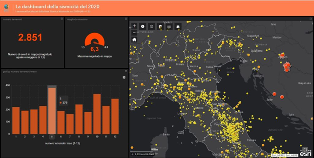
“Con questa applicazione abbiamo classificato i terremoti di magnitudo maggiore o uguale a 1.5. I visitatori possono vedere per ogni evento i relativi parametri ipocentrali” evidenzia Maurizio Pignone, che prosegue “Inoltre, con le infografiche abbiamo voluto mettere a disposizione del pubblico uno strumento di maggiore chiarezza possibile, giacché sono visualizzabili tutti i terremoti anche per singole aree liberamente scelte dall'utente, con la magnitudo massima e la loro distribuzione nei 12 mesi dell'anno”.
“La rappresentazione grafica degli eventi sismici verificatisi in Italia è uno strumento fondamentale che l’INGV mette a disposizione dei cittadini e della comunità scientifica per incrementare la consapevolezza della fragilità dei nostri territori lungo tutta la penisola, oltre che a dare uno strumento di ricerca agli studiosi di tutto il mondo. Nonostante la grave crisi sanitaria, la sorveglianza sismica effettuata dall’INGV nel 2020 non si è fermata neanche un secondo. L’informazione è un’attività che l’Istituto persegue costantemente con le azioni di divulgazione della ricerca e del monitoraggio e che, per quanto riguarda i terremoti, si concretizzano anche nelle iniziative promosse in occasione della Giornata della Alfabetizzazione Sismica del mese di gennaio di ogni anno: la Terra è un pianeta vivo, l’Italia continuerà sempre ad avere terremoti e dobbiamo investire nella loro maggiore conoscenza per difenderci meglio in futuro”, conclude il prof. Carlo Doglioni, Presidente dell’INGV.
Link al Blog INGVterremoti
Link alle Story map di INGVterremoti
Link alla mappa interattiva dei terremoti del 2020
---
INGV special, the earthquakes of 2020 in Italy
Also in 2020 an average of 45 earthquakes per day has been located by the Institute's 24-hour operational surveillance rooms: about 1 every 30 minutes.
In the "Special 2020" of the INGVterremoti Blog, you can "navigate" among the seismic events with interactive maps, story maps and infographics.
During 2020, the National Seismic Network of the Italian National Institute of Geophysics and Volcanology (INGV) located 16,597 earthquakes on the Italian territory and in the surrounding areas. An average of about 45 earthquakes per day with an average interval of one event every half hour.
"The map we made this year shows that in 2020 the strongest earthquakes were located outside the Italian territory. The seismic events with magnitude equal to or greater than 5.0 have occurred in Albania, Algeria, and Croatia during the seismic sequence at the end of the year with the strong earthquake of magnitude Mw 6.3 on December 29, near the city of Petrinja ", says Alessandro Amato, INGV seismologist, who underlines "The number of earthquakes located in Italy in 2020 is very similar to that of 2019, a lower number when compared with 2016 and 2017, characterized by the long seismic sequence in Central Italy, which began on August 24, 2016".
The first earthquake of 2020 occurred on January 1st, 2020 in Sefro (MC) only one minute and 24 seconds after the stroke of midnight and the last, on the other hand, on December 31st, 2020 at 23:41 in Ragalna (CT), both with a magnitude of less than 2.0.
As always, Sardinia is confirmed as the region with the lowest number of earthquakes. Also counting the marine areas around the island, in the 366 days of 2020 only 4 were recorded.
"Almost 90% of the earthquakes located in Italy in 2020 had a magnitude lower than 2.0 and, probably, they were not felt by the population, with some exceptions in the case of very shallow hypocenters and epicenters near inhabited areas, such as those that occurred in the volcanoes in Campania", explains Maurizio Pignone, INGV geologist, who continues "Most earthquakes are linked to seismic sequences, which occurred in Italy in 2020. Others, however, are considered "isolated" shocks, as for example the earthquake in Milan of December 17, of magnitude 3.8".
The earthquakes that have marked 2020 are "navigable" with an interactive map and with a story map created by the INGV Terremoti Team.
"With this application we have selected earthquakes with magnitude greater than or equal to 1.5. Visitors can see the hypocentral parameters for each event" underlines Maurizio Pignone, who continues "Furthermore, with the infographics we wanted to offer the public a tool as friendly as possible, since all earthquakes can also be viewed for specific areas freely chosen by the user, with the maximum magnitude and their distribution over the 12 months of the year".
"The geographic representation of the seismic events that occurred in Italy is a fundamental tool that the INGV makes available to citizens and the scientific community to increase awareness of the fragility of our territories throughout the peninsula, as well as providing a research tool for scholars from all over the world. Despite the serious health crisis, the seismic surveillance carried out by the INGV in 2020 did not stop for even a second. Information is an activity that the Institute constantly pursues with the dissemination of research and monitoring and which, as regards earthquakes, are also reflected in the initiatives promoted on the occasion of the Day of Seismic Literacy, scheduled every year in January: the Earth is a living planet, Italy will always continue to have earthquakes and we must invest in their greater knowledge to better defend ourselves in the future ", concludes prof. Carlo Doglioni, President of INGV.
Blog INGVterremoti
Story map of INGVterremoti
Link to the interactive map of 2020 earthquakes