

Note Press
Rome, August 24 2017
The macroseismic reliefs of the 2016-2017 earthquakes in central Italy
Video interview with the seismologist Andrea Tertulliani
https://youtu.be/tZJBxBYu-qg
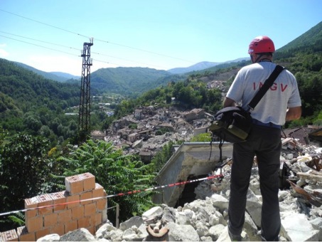
In case of a strong earthquake it is expected that theIstituto Nazionale di Geofisica e Vulcanologia (INGV) deploys teams for the macroseismic relief. These are hidden behind the acronym QUEST (Quick Earthquake Survey Team) and are made up of experts who are dedicated to post-earthquake macroseismic survey. The teams, which also collaborate with the Civil Protection Department, have the task of providing, relatively quickly, the picture of the damage due to the seismic event in terms of macroseismic intensity. The survey is carried out by collecting data on the quantity of damaged buildings, their typology and vulnerability and on the kind of damage suffered.
The QUEST team was also very active during the long and dramatic seismic sequence that hit central Italy in 2016-2017, carrying out repeated surveys after each of the strongest shocks that affected the area between Marche, Umbria, Lazio and Abruzzo (24 August, 26 and 30 October 2016, 18 January 2017). Overall, starting from the afternoon of 24 August 2016 until the end of February 2017 they were executed four surveys in which 25 expert surveyors from 7 sections of the INGV took turns on the territory(Bologna, Catania, Milan, Pisa and the 3 sections of Rome), plus some detectors from ENEA and the Eucentre in Pavia. In all, about 330 localities were surveyed, most of which have been investigated multiple times e to which macroseismic intensity values have been assigned both in the MCS scale (Sieberg, 1930) that EMS98 (Grünthal, 1998). For further information on the methods and the different types of survey and on the use of the two macroseismic scales, see in-depth post on this blog.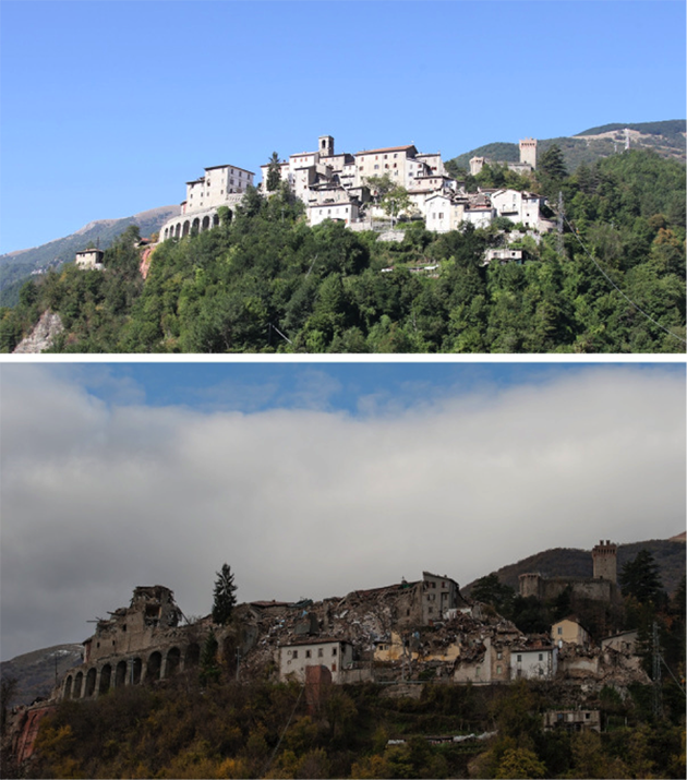
After the earthquake of 24 August 2016, the town of Arquata del Tronto (AP) showed effects of grade 8-9 both MCS and EMS (top). After the events of 26 and above all of 30 October 2016, the scenario has become much worse, reaching effects equal to degree 10 MCS (and 9-10 EMS) - (Photo QUEST).
According to the usual modalities of the macroseismic survey conducted for some time by INGV, the survey was carried out in the area of greatest damage, observing the damage visible on the outside of the buildings and focusing the investigation on civil and residential construction as it is more representative from a macroseismic point of view. This is because the attribution of intensity, especially in EMS, mainly takes into account the effects on residential construction based on the building typologies and the resentment in the population.
The vastness of the area affected by the whole sequence, characterized by strong heterogeneity in the building typologies and great variability in the levels of damage found within the individual towns and cities, makes a synthesis necessary here which cannot be exhaustive. For more details and insights, see the publications and reports listed in the bibliography (Tertulliani and Azzaro, 2016, 2017; QUEST Working Group, 2016; Galli et al. 2016); some QUEST reports are published and available on the web page http://quest.ingv.it/index.php/rilievi-macrosismici.
Observing the area of the damage, it can be seen that since the earthquake of 24 August 2016 the most serious and destructive effects have been distributed in the NNW-SSE direction, with a greater propagation towards the north, in the Marche. At the opposite, strong attenuations of the effects occurred towards S-SE (after 24 August in the Campotosto area, a few km south of Amatrice, no significant damage was observed) and in W-SW direction. The maximum levels of damage caused by the earthquake of 24 August (Is ≥ 10 for both MCS and EMS) sThey have been recognized in some localities distributed on the right side of the Tronto valley (on the slopes of Laga), with the exception of Pescara del Tronto (fraction of Arquata del Tronto), located on the left(slopes of the Sibillini).
The earthquakes of 26 and above all of 30 October greatly aggravated the damage and extended it to a much larger area than that already damaged on 24 August, always maintaining the same NNW-SSE direction, parallel to that of the faults that generated the various main shocks.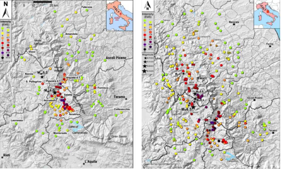
Distribution of EMS intensity values after the earthquake of 24 August 2016 (Mw 6.0 and Mw 5.3) – on the left – and after the events of 26 (Mw 5.4 and 5.9) and 30 October 2016 (Mw 6.5) – on the right. Note the sharp aggravation following the aftershocks at the end of October and the extension of the damage especially towards the north.
The severity of the effects and their distribution on the territory can be partly explained by three reasons:
- to the seismic source directivity, i.e. the direction in which the ruptures of the individual fault segments propagated during the main events. For example, following the Mw 6.5 magnitude earthquake of 30 October, a strong attenuation of the intensity in the W and SW direction was noted (overall light or negligible damage to Cascia [6-7 EMS over the entire town, but only 5 EMS in the historical centre], Cerreto di Spoleto [5EMS] etc. a few km from the epicenter) opposed to a strong propagation of the shaking towards N and NE (widespread and important damage to Dressing room [7-8 EMS], Tolentino [7 EMS], San Severino Marche [7 EMS], San Ginesio [7-8 EMS] etc., at significant distance from the epicenter);
- b) the high seismic vulnerabilityof buildings in some areas. The historic buildings present in the towns of Upper Reatino and the neighboring province of Ascoli Piceno, along the Valle del Tronto, are generally very different and considerably more vulnerable than those which characterize both the Valnerina, in Umbria (Norcia-Preci area -Cascia), and the Marche side of the Sibillini Mountains (provinces of Macerata and Fermo). In fact, in the Rieti area and in the Valle del Tronto, the inhabited centers present a strong prevalence of historic stone buildings; the minor centres, which originally arose as rural settlements, were progressively used for residential use (mainly second homes) or partially abandoned.
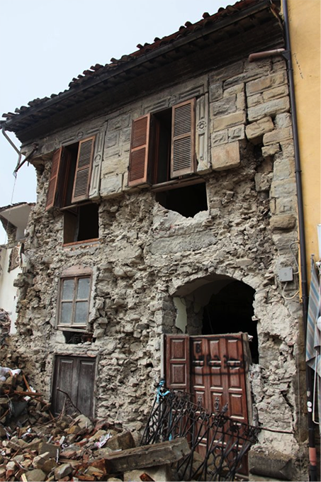
Amatrice: building with double facing masonry, with load-bearing walls built with stones of various sizes, poorly assembled and with poor binders. An example of high seismic vulnerability (Photo QUEST).
The traditional building material is generally the one immediately available on site and, in some sectors in particular (for example in the hamlets of Amatrice on the Monti della Laga side), it consists of stones of extremely varied size, generally rounded or only roughly hewn, assembled inconsistently and without mortars. The load-bearing walls, in several cases, are made up of double facing walls, not connected ("sack" masonry).
Furthermore, many buildings show traces of relatively recent renovations which however achieved the opposite effect, worsening the vulnerability and making these structures more fragile. For example, many wooden floors have been replaced over time with rigid and heavy brick and concrete floors, without adequate reinforcement of the old vertical masonry and without an adequate connection between the masonry and the floor, thus compromising the integrity of the entire structure. The insertion of concrete curbs is quite frequent, often unreinforced or with totally inadequate reinforcement (in some cases on only one side of the building).
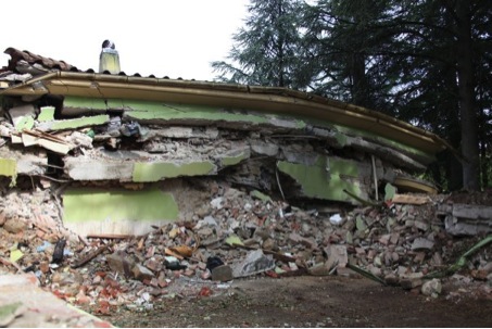
Amatrice: building collapsed due to the weight of reinforced concrete roofs and floors weighing on fragile and vulnerable masonry, not designed to support them (Photo QUEST).
From all these considerations it is not surprising that already following the earthquake of 24 August 2016, with its epicenter in this area, the effects were highly destructive, with high mortality.
In other sectors – above all on the Marche side to the east of the Apennine chain – a much less vulnerable building in masonry with squared stone with brick recourses is widespread. In these areas, however, other factors also came into play.

In the areas of Umbria and Marche affected by reconstructions and restructuring following recent earthquakes (Valnerina 1979, Umbria-Marche 1997-98) the degree of damage was much more contained, even after the three main events of 24 August, 26 and 30 October. In the photo examples of buildings in Preci (PG), above, and in Sarnano (MC), below.
The Valnerina area, for example, was the site of strong and repeated earthquakes in the past centuries (in the years 1703, 1730, 1859 and 1979 the strongest of the last 3 centuries, plus numerous other minor ones - see CPTI15 (Rovida et al., 2016) which resulted in frequent reconstructions and renovations. To these must also be added the recent and "virtuous" renovations following the Umbria-Marche earthquake of 1997-98, clearly visible, for example, in the chains inserted in numerous walls. This is probably one of the determining elements which explains why in towns like Norcia and Preci the damage to the historic centers was relatively limited – it was above all the churches that suffered vast collapses (on the particular vulnerability of churches, and of monumental buildings in general, refer to the July post) – despite the proximity to the epicenter of the very strong shock of 30 October. Similarly, several localities on the Marche side are also characterized by the presence of buildings rebuilt or reinforced after 1997 and which therefore present overall less vulnerability;
- c) local amplification effects( "site effects”), such as “ridge” or “saddle” effects that amplified the seismic shaking. This is the case of centers such as Loving it(FM) and Gualdo(MC), already extensively damaged by the shock of August 24 and aggravated after October 26 and 30, or San Severino Marche (MC), very far from the epicenter. Other examples are represented by the same Amateur (PGA of 0.86 g for the earthquake of August 24) and some of its fractions located north and east of the capital at the foot of the Laga (for example Saletta, Sommati, Casale, San Lorenzo and Flaviano), all centers characterized, as we have seen above, by a high vulnerability which was further aggravated by the seismic amplification due to the presence of recent and incoherent Quaternary sediments on which these villages had been built. The hamlets located west of Amatrice, located on the sandstones of the Laga formation, where the seismic amplification was less, suffered more limited damage.
A special case is represented by the town of Pescara del Tronto, probably founded on the accumulation of an ancient landslide (paleolandslide) remobilized during the main shock of August 24, right in the area of the seismogenic fault.
The strong building vulnerability and the local effects of particular sites are at the origin of the high degree of destruction (Int. 10-11 MCS and 10 EMS already with the earthquake of 24 August) found in Pescara del Tronto (AP), built on a paleolandslide in the fault area (Photo QUEST).
The combination of all these elements contributed to produce – following the earthquakes of 2016-2017 – un level of damage among the highest observed in Italy in the last 100 years. In the Amatrice area and in Pescara del Tronto already following the earthquake of Mw 6.0 of August 24, effects equal to degree 10 EMS (and 10-11 MCS) were reached, which worsened after the events of 26 and above all of 30 October, reaching full grade 11 in both EMS and MCS. Effects of this gravity (11 MCS) - even if "cumulative" due to the repeated, violent shocks - have not been observed in our country for over a century, that is since the times of the famous and catastrophic earthquakes of 28 December 1908 in Messina-Reggio Calabria and of 13 January 1915 in Marsica (Abruzzo) (CPTI15; Rovid et al., 2016).
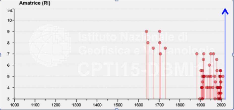
The seismic history of Amatrice (from DBMI15; Locati et al, 2016) has been known since the 1639 earthquake (Mw 6.2 CPTI15; Rovida et al., 2016) and up to now had maximum seismic effects equal to MCS grade 9. The blue arrow on the right indicates the devastating degree 11 MCS (and EMS) due to the cumulative effects produced by the 2016-2017 sequence, and represents the historical maximum reached for this locality (NB: This figure does not appear in the DBMI15 database, as the current version of the CPTI15 catalog is updated to 2014).
Lo overall damage scenario, detected after the last strong tremors of 18 January 2017, with serious damage extended for about 70 km from the area of Campotosto (AQ) and from Teramo, to the south, up to San Severino Marche and Tolentino to the north, it is among the largest, most serious and destructive observed in the last century in Italy.
with Matthijs Ronner and Robbert Liekens from Filippo Bernardini (INGV – Bologna) and Andrea Tertulliani (INGV - Rome1).
Link to the INGVterremoti blog: