

Accessibility
The official Accessibility Statement will be published shortly. Please note that the related technical analyses are currently being carried out by specialized third parties. Once these checks and any remediation activities for identified issues have been completed, the final document will be published.
Seismic events in the province of Perugia, 9 March 2023
From the afternoon of the March 9, 2023 the National Seismic Network has located numerous seismic events in the area of umbertide in the province of Perugia. At 09:30 on 10 March 2023 there are about 70 earthquakes registered, only 8 of magnitude greater than 2.0.

The map shows the two highest magnitude events: the magnitude earthquake ML 4.6 (Mw 4.5) of the hours 20:08 and that of the hours 16:05 of magnitude ML 4.4 (Mw 4.3). These two main events were widely felt not only in northern Umbria but throughout the Region and in some surrounding areas of neighboring Regions such as Tuscany, Marche and Lazio.
ARTICLES PUBLISHED ON INGVterremoti.com
Seismic event of 9 March 2023, ML 4.6 in the province of Perugia
https://ingvterremoti.com/2023/03/09/evento-sismico-del-9-marzo-2023-ml-4-6-in-provincia-di-perugia/
Seismic event of 9 March 2023, ML 4.4 (Mw 4.3) in the province of Perugia
https://ingvterremoti.com/2023/03/09/evento-sismico-del-9-marzo-2023-ml-4-4-mw-4-3-in-provincia-di-perugia/
Do you know how to behave in case of an earthquake?
WHAT TO DO
https://www.iononrischio.it/it/rischi/terremoto/cosa-fare


Earthquakes in Venezuela June 2026
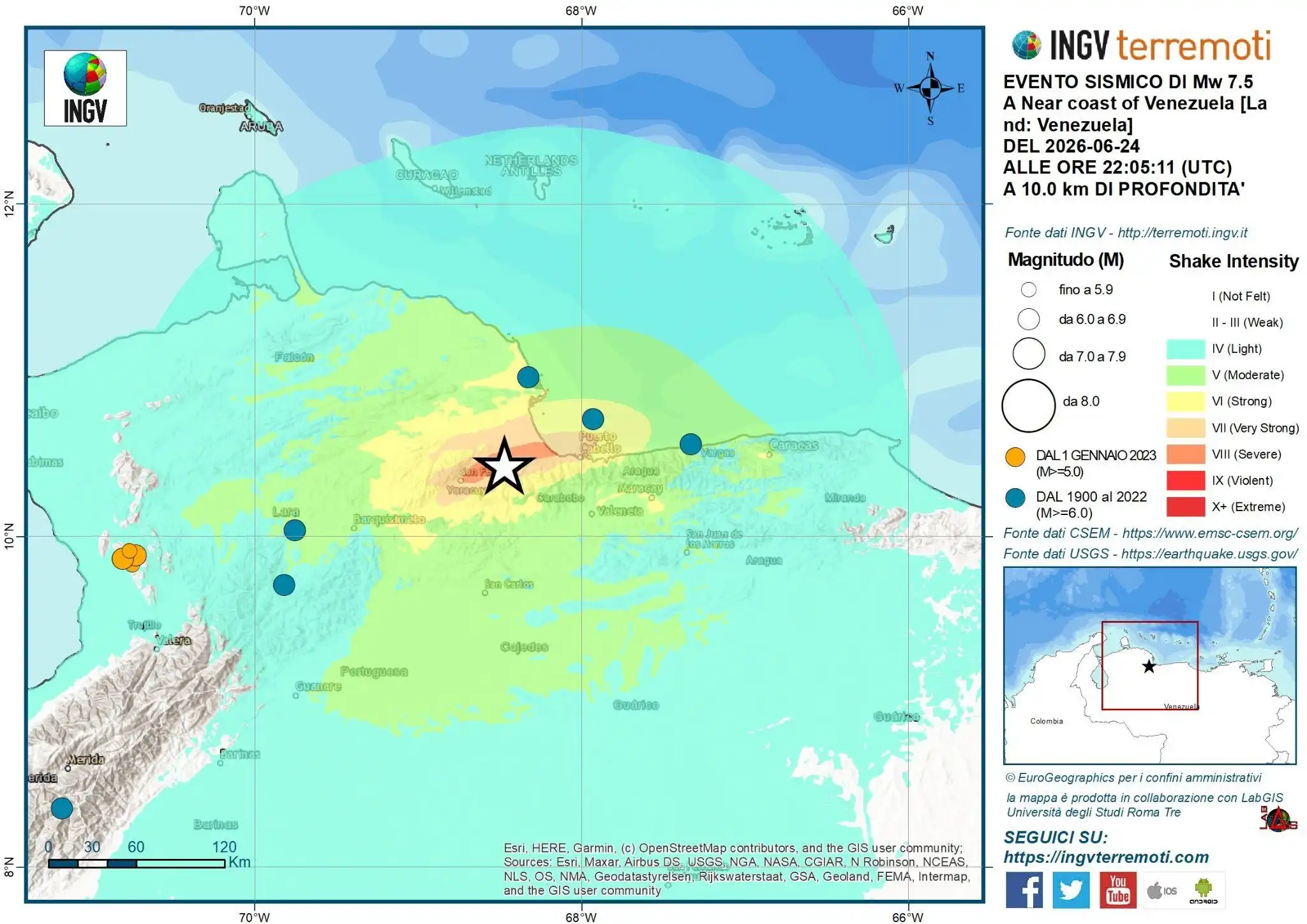
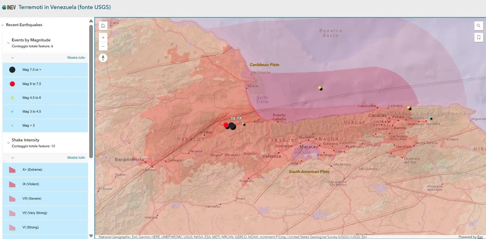
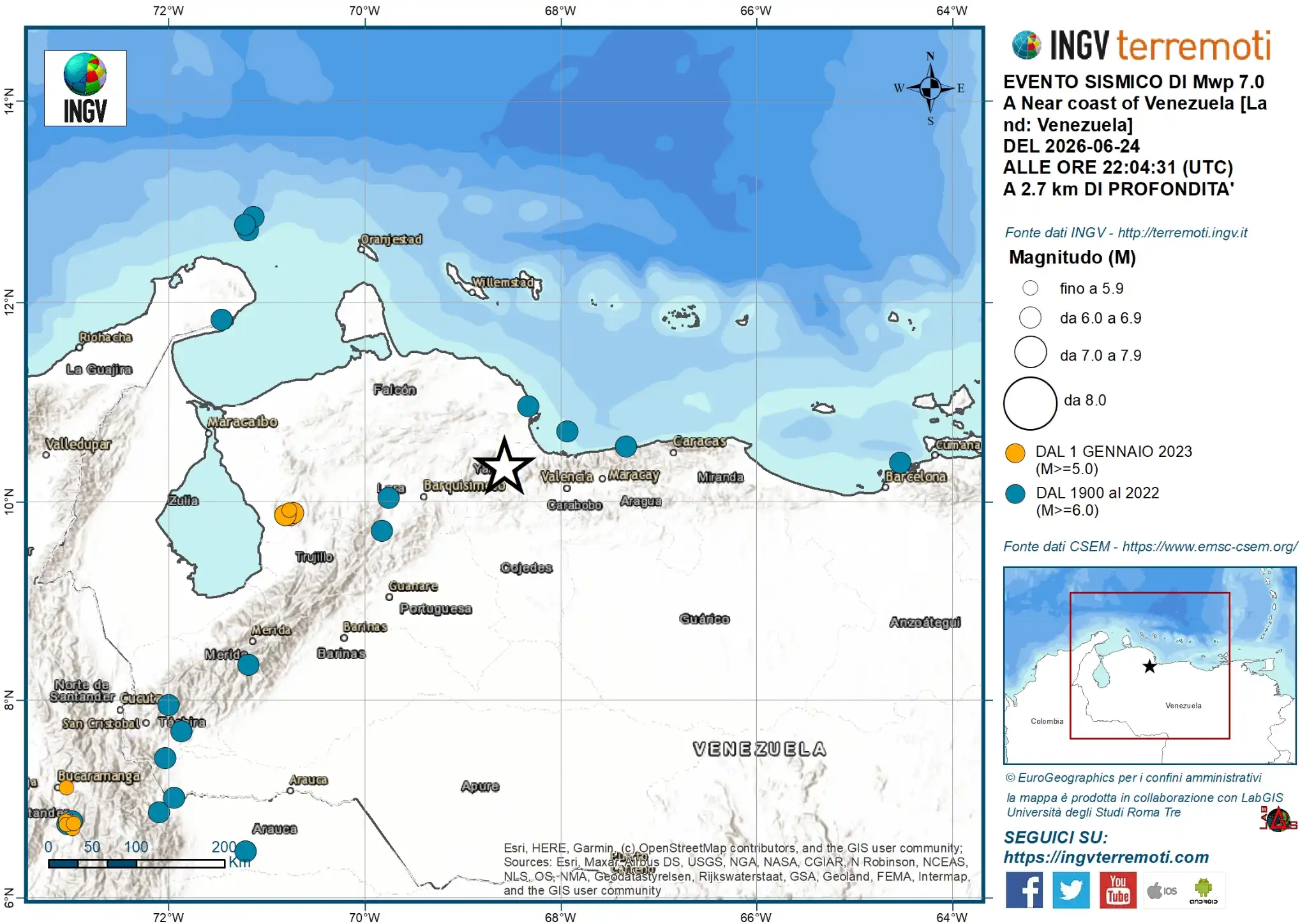
In night between June 24 and 25, 2026 the northern coast of Venezuela was hit by a seismic sequence, with two strong events, estimated by theUSGS respectively of magnitude 7.2 e 7.5, located in the Morón area and also felt disastrously in the region of the capital Caracas.
Northern Venezuela lies along the complex margin between the Caribbean plate (to the North) and the South American plate (to the South). The relative motion between the two has a significant component of right-hand sideThe main active faults that accommodate this movement are the system Boconó–San Sebastián–El Pilar and the system Goose–Ancón.
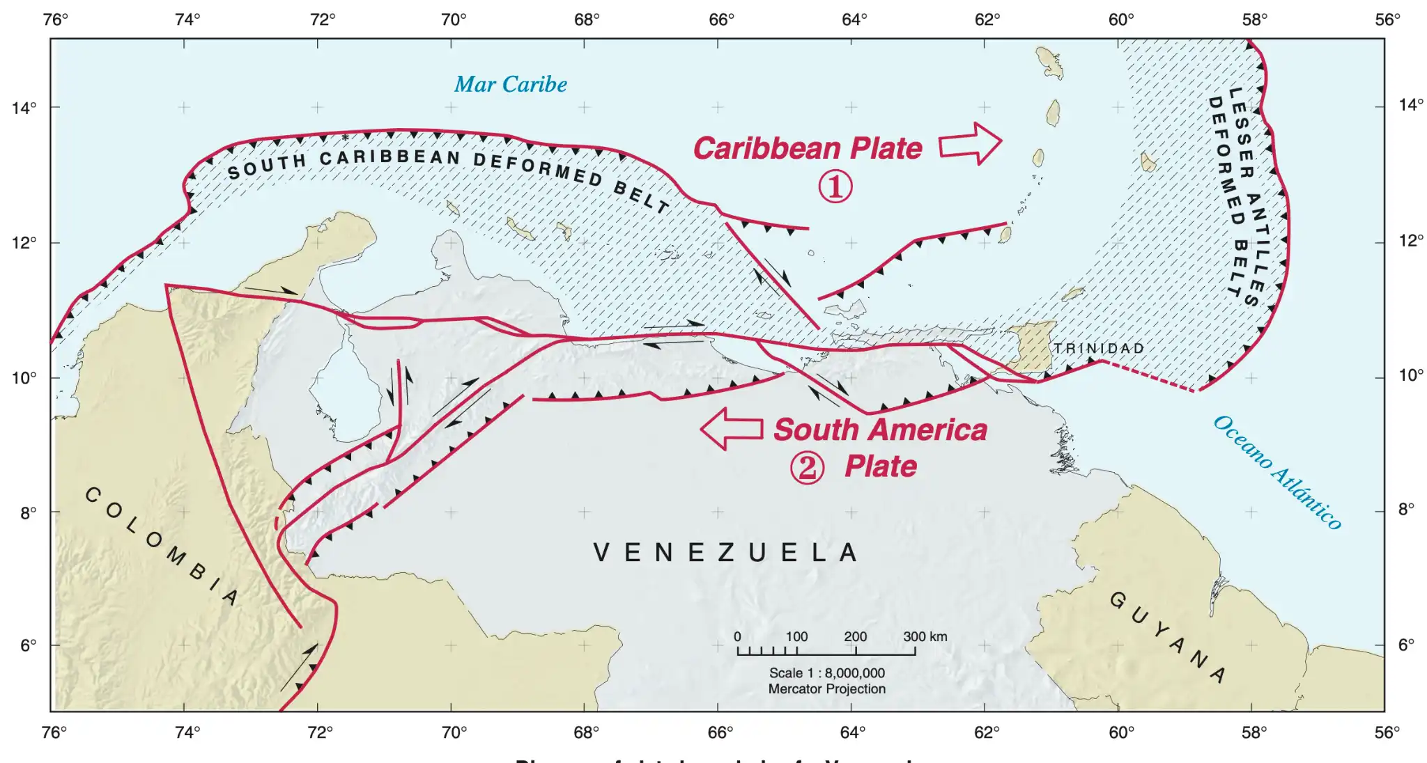
Map of plate boundaries in the Venezuelan region, from “Map of Quaternary Faults of Venezuela, Franck A. Audemard M. 2000, USGS report ofr-00-0018"
WEBGIS TO FOLLOW THE PROGRESS OF THE SEQUENCE
ARTICLES PUBLISHED ON INGVterremoti.com
https://ingvterremoti.com/category/terremoti_mondo/terremoti-in-venezuela-2026
Smartphones and early warnings in Venezuela: truth or myth?

Extended source of the earthquake sequence in Venezuela, June 24, 2026
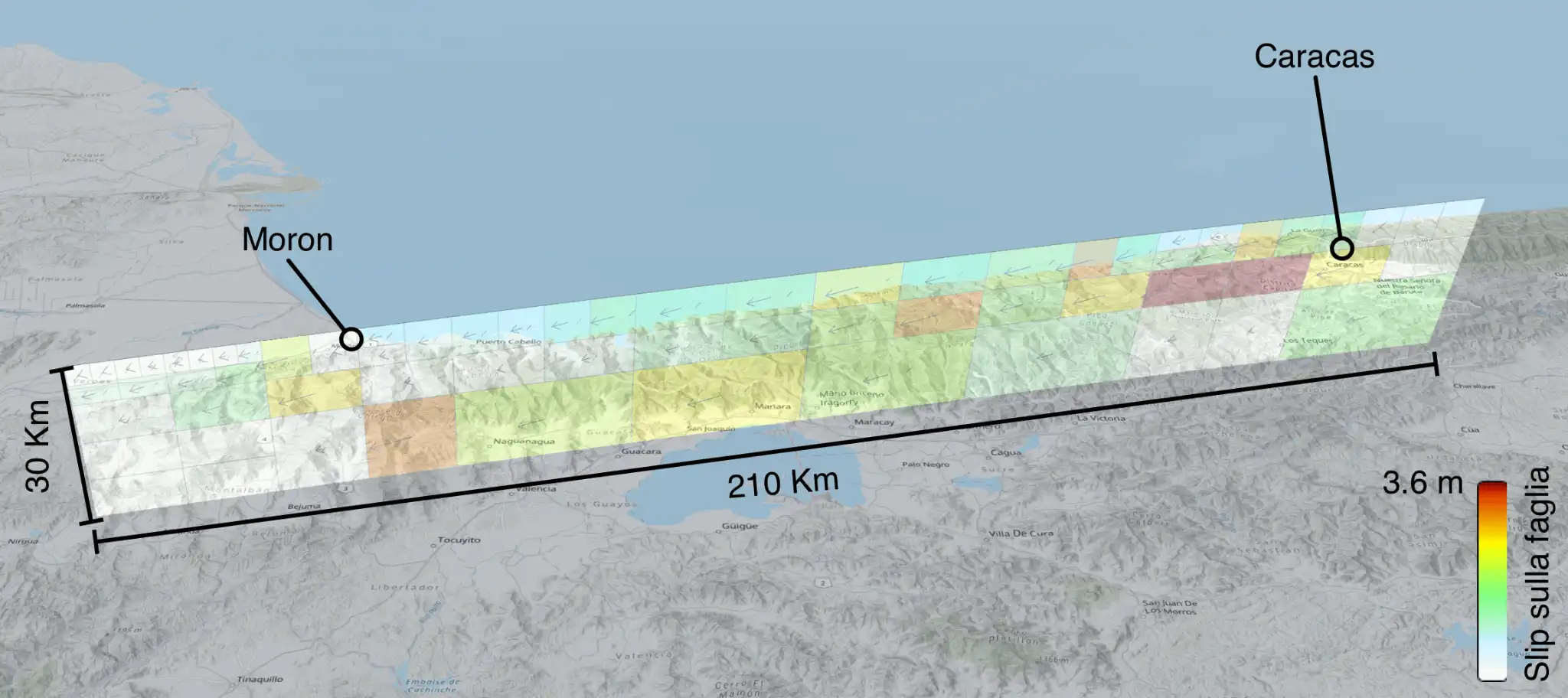
Seismic events Mw 7.0 and 7.5, state of Yaracuy (Venezuela), June 24, 2026
LINK FOR FURTHER INFORMATION
USGS
https://earthquake.usgs.gov/earthquakes/eventpage/us6000t7zp/executive
Seismic sequence in southeastern Turkey
On February 6, 2023 at 02:17 Italian time (04:17 local time) Turkey was hit by an earthquake with a magnitude of 7.9 (Mw 7.7 according to AFAD estimates, Turkish Emergency and Disaster Management Agency). The earthquake hit the regions of southern Turkey and northern Syria, a highly seismic area, among those with the highest seismic hazard in the Mediterranean. The earthquake was followed by numerous aftershocks of even high magnitude and a new very strong shock, M 7.5, was recorded at 11:24 Italian time with the epicenter north of the 02:17 event. Tens of thousands of people lost their lives and many more were injured, with damage to buildings and infrastructure widespread across the region. The tremors continued over the following days. Turkey and Syria sit on a series of active faults, such as the East and North Anatolian faults, which mark the boundary between several tectonic plates, including the Anatolian, Eurasian and Arabian plates. The two earthquakes on Monday 6 February occurred on different segments of the East Anatolian fault system. Both earthquakes occurred at a relatively shallow depth, the first at a depth of about 18 km, the second at a depth of about 10 km, and together they ruptured several segments of the East Anatolian Fault, currently estimated at between 500 and 600 km. .

Seismicity map updated at 11:00 on 24 February 2023
(source CSEM - https://www.emsc-csem.org/Earthquake/Map/gmap.php)
ARTICLES PUBLISHED ON INGVTERREMOTI.COM
(https://ingvterremoti.com/category/terremoti_mondo/terremoti-in-turchia-2023/)
The amplification of the seismic motion in the Po Valley during the earthquake in Turkey of 6 February 2023, Mw7.9, recorded by the stations of the National Seismic Network
https://ingvterremoti.com/2023/02/27/lamplificazione-del-moto-sismico-in-pianura-padana-durante-il-terremoto-in-turchia-del-6-febbraio-2023-mw7-9-registrato-dalle-stazioni-della-rete-sismica-nazionale/
Satellite analysis of the deformation induced by the seismic events in Turkey on February 6, 2023
https://ingvterremoti.com/2023/02/22/analisi-satellitare-della-deformazione-indotta-dagli-eventi-sismici-in-turchia-del-6-febbraio-2023/
Mwp 6.3 seismic event Turkey, February 20, 2023
https://ingvterremoti.com/2023/02/20/evento-sismico-mwp-6-3-turchia-20-febbraio-2023/
The East Anatolian Fault (Turkey): from the Elazig earthquake, M 6.8, of January 24, 2020 to the Pazarcik-Gaziantep earthquake, M 7.7, of February 6, 2023
https://ingvterremoti.com/2023/02/20/la-faglia-est-anatolica-turchia-dal-terremoto-di-elazig-m-6-8-del-24-gennaio-2020-al-terremoto-di-pazarcik-gaziantep-m-7-7-del-6-febbraio-2023/
Historic earthquakes in Southeastern Anatolia: some cases from ongoing research
https://ingvterremoti.com/2023/02/19/terremoti-storici-in-anatolia-sud-orientale-alcuni-casi-da-una-ricerca-in-corso/
The earthquake in Turkey of February 6, 2023 registered in Antarctica
https://ingvterremoti.com/2023/02/13/il-terremoto-in-turchia-del-6-febbraio-2023-registrato-in-antartide/
February 6, 2023 Turkey Earthquake Update – February 11, 2023
https://ingvterremoti.com/2023/02/11/aggiornamento-sul-terremoto-del-6-febbraio-2023-in-turchia-11-febbraio-2023/
Preliminary analysis of the accelerometric recordings of the earthquake in Turkey (Mw 7.9) of February 6, 2023
https://ingvterremoti.com/2023/02/09/analisi-preliminare-delle-registrazioni-accelerometriche-del-terremoto-in-turchia-mw-7-9-del-6-febbraio-2023/
Deformation processes in the Aegean-Anatolian area: what we know
https://ingvterremoti.com/2023/02/09/i-processi-di-deformazione-nellarea-egeo-anatolica-cosa-ne-sappiamo/
The tsunami warning for the earthquake in Turkey of February 6, 2023
https://ingvterremoti.com/2023/02/06/lallerta-tsunami-per-il-terremoto-in-turchia-del-6-febbraio-2023/
Seismic events update in Turkey of February 6, 2023
https://ingvterremoti.com/2023/02/06/aggiornamento-eventi-sismici-in-turchia-del-6-febbraio-2023/
New M 7.5 seismic event in Turkey, February 6, 2023
https://ingvterremoti.com/2023/02/06/nuovo-evento-sismico-m-7-5-in-turchia-6-febbraio-2023/
M 7.9 seismic event in Turkey, February 6, 2023
https://ingvterremoti.com/2023/02/06/evento-sismico-m-7-9-in-turchia-6-febbraio-2023/
WEB SITES TO FOLLOW THE PROGRESS OF THE SEQUENCE
KANDILLI OBSERVATORY AND EARTHQUAKE RESEARCH INSTITUTE (KOERI)
http://udim.koeri.boun.edu.tr/zeqmap/hgmmapen.asp
AFAD - Disaster And Emergency Management Presidency
https://deprem.afad.gov.tr/last-earthquakes.html
MORE
WEBGIS SPACE-TIME TREND SEQUENCE (USGS dataset)
https://ingv.maps.arcgis.com/apps/instant/slider/index.html?appid=8a4f91d8da604b08be619d981d70d2d2
EARTHQUAKE SEQUENCE IN TURKEY (CSEM)
https://www.emsc-csem.org/Earthquake/271/Earthquake-sequence-in-Turkey-February-6th-2023
STORY MAPS
THE 2023 KAHRAMANMARAŞ, TURKEY, EARTHQUAKE SEQUENCE
https://earthquake.usgs.gov/storymap/index-turkey2023.html

THE DEVASTATING EARTHQUAKE IN TURKEY AND SYRIA https://www.reuters.com/graphics/TURKEY-QUAKE/zdvxdngmzvx/
MAPPING THE DAMAGE FROM THE EARTHQUAKE IN TURKEY AND SYRIA https://www.nytimes.com/interactive/2023/02/06/world/turkey-earthquake-damage.html
#ExeStretto22 | EXERCISE Earthquake in the Reggio Calabria and Messina Straits, 4-6 November 2022
Updates from INGVterremoti.com
- LINK INGVterremoti.com article on the Ml 6.0 (Mw 6.2) earthquake
- LINK article INGVterremoti sequence update
- LINK article INGVterremoti animation shakemovie
Detail reports
- Seismic Room official detailed report for event Ml 6.0 (Mw 6.2)
- Seismic Room official detailed report for event Ml 4.6
Sequence update maps
- Sequence map at 12:00
- Sequence map at 13:00
- Sequence map at 15:00
Videos and animations
- Shakemovie event Ml 6.0 (Mw 6.2)
Activity reports Emergency Operations Groups
Summary report
when it's ready