


Uno studio dell’INGV suggerisce che la particolare morfologia dei calanchi marziani sia dovuta all'erosione causata dall’azione di acqua liquida che affiorerebbe in presenza di condizioni ambientali favorevoli
I calanchi presenti su Marte, noti come "gullies", potrebbero essere originati dall’azione di acqua allo stato liquido. È questa l’ipotesi dello studio frutto dell’intuizione di un ricercatore dell’Istituto Nazionale di Geofisica e Vulcanologia (INGV) e pubblicato sulla rivista ‘Italian Journal of Geosciences’.
Sulla Terra i calanchi sono dei profondi solchi nel terreno prodotti per lo più dallo scorrimento delle acque su rocce argillose, con scarsa copertura vegetale e, quindi, poco protetti dal ruscellamento. Si presentano lungo il fianco di un monte o di una collina rappresentando percorsi delle acque stretti e affilati. Sempre sulla Terra i calanchi si trovano prevalentemente esposti al mezzogiorno (a sud nel nostro emisfero) perché il fenomeno erosivo sull’argilla è condizionato dall’esposizione al Sole. Al contrario su Marte i “gullies” sono rivolti prevalentemente verso i poli, come se avessero bisogno di mantenersi a bassa temperatura, analogamente ai ghiacciai terrestri. Questo paradosso può avere una spiegazione fisica
“I calanchi marziani, scoperti nel 2000 grazie alla sonda spaziale Mars Global Surveyor sulle scarpate di alcune regioni del pianeta rosso”, spiega Adriano Nardi, ricercatore dell’INGV e autore dello studio, “potrebbero essere interessati da fenomeni di sorgività stagionale influenzata dalla variabilità delle condizioni meteorologiche esterne; le sorgenti d’acqua, si attiverebbero solo in presenza di determinate condizioni ambientali, di pressione e di temperatura. Al fine di indagare questo fenomeno abbiamo proposto un nuovo modello fisico denominato Weather-Springing Water (WSW)”.
La possibilità che i gullies si fossero prodotti a seguito di liquefazione di ghiaccio presente nel sottosuolo (cd. permafrost) sembrava impossibile date le condizioni climatiche presenti sul pianeta rosso. Tuttavia, nell'arco dell’ultimo ventennio, sono state osservate diverse mutazioni nella loro morfologia, così come la comparsa di nuove strutture morfologiche.
“Le osservazioni geomorfologiche delle immagini e le simulazioni numeriche delle condizioni atmosferiche", prosegue il ricercatore, “hanno indicato che la pressione e la temperatura presenti nel sottosuolo potrebbero favorire la fusione del permafrost e in questo modo il fenomeno di affioramento avverrebbe dove la falda acquifera incontra una scarpata, ma solo quando all’esterno si verificano condizioni atmosferiche particolari”.
Considerata l'elevata instabilità dell’acqua su Marte, una volta affiorata in superficie essa tenderà a scomparire rapidamente. Con il modello fisico ideato dai ricercatori INGV è risultato tuttavia che l’acqua, prima di evaporare, avrebbe il tempo necessario per attraversare ed erodere questi canali per l’intera lunghezza delle morfologie osservate.
“Le simulazioni effettuate hanno mostrato che il fenomeno di sorgività si manifesta solo sporadicamente”, conclude Adriano Nardi. “Si tratta di un evento meteorologico-geologico, in grado di determinare le particolari caratteristiche morfologiche e geografiche dei gullies marziani, altrimenti difficili da spiegare. La ricerca continua, anche nell'ottica di identificare potenziali sorgenti d'acqua da utilizzare nello scenario di una futura colonizzazione del pianeta”.
Nardi A. & Piersanti A. (2022) - "Geomorphologic observations and physical hypothesis on Martian gullies". Ital. J. Geosci., Vol. 141(2), 245-258.
---
MARS | The presence of liquid water in the Martian badlands has been studied by means of a new physical model
An INGV study suggests that the particular morphology of the Martian gullies is due to erosion caused by the action of liquid water that would emerge in the presence of favorable environmental conditions
The badlands present on Mars, known as "gullies", could have originated from the action of liquid water. This is the hypothesis of the study ", the result of the intuition of a researcher from the Istituto Nazionale di Geofisica e Vulcanologia (INGV) and published in the 'Italian Journal of Geosciences'.
On Earth, gullies are deep furrows in the ground produced mostly by the flow of water on clayey rocks, with scarce vegetation cover and, therefore, poorly protected from runoff. They occur along the side of a mountain or a hill representing narrow and sharp waterways. Also on Earth, the gullies are mainly exposed to the south (to the south in our hemisphere) because the erosive phenomenon on the clay is conditioned by exposure to the Sun. On the contrary, on Mars the "gullies" are mainly facing the poles, as if they needed to maintain a low temperature, similar to terrestrial glaciers. This paradox can have a physical explanation.
"The Martian gullies, discovered in 2000 thanks to the Mars Global Surveyor space probe on the slopes of some regions of the red planet", explains Adriano Nardi, researcher at INGV and author of the study, "could be affected by seasonal spring phenomena influenced by variable external weather conditions; the water sources would be activated only in the presence of certain environmental conditions, pressure and temperature. In order to investigate this phenomenon, we have proposed a new physical model called Weather-Springing Water (WSW)”.
The possibility that the gullies were produced as a result of the liquefaction of ice present in the subsoil (so-called permafrost) seemed impossible given the climatic conditions present on the red planet. However, over the last twenty years, several mutations have been observed in their morphology, as well as the appearance of new morphological structures.
"The geomorphological observations of the images and the numerical simulations of atmospheric conditions", continues the researcher, "indicated that the pressure and temperature present in the subsoil could favor the melting of the permafrost and in this way the outcrop phenomenon would occur where the aquifer meets an escarpment, but only when particular atmospheric conditions occur outside”.
Water is quite unstable on Mars and once it reaches the surface it tends to disappear quickly. However, with the physical model conceived by INGV researchers, it was found that the water, before evaporating, would have enough time to flow and erode these channels for the whole length of the observed morphologies.
“The simulations carried out have shown that the phenomenon of spring occurs only sporadically”, concludes Adriano Nardi. “It is a meteorological-geological event, capable of determining the particular morphological and geographical characteristics of the Martian gullies, otherwise difficult to explain. Research continues, also with a view to identify potential water sources to be used in the scenario of a future colonization of the planet”.
Nardi A. & Piersanti A. (2022) - "Geomorphologic observations and physical hypothesis on Martian gullies". Ital. J. Geosci., Vol. 141(2), 245-258.
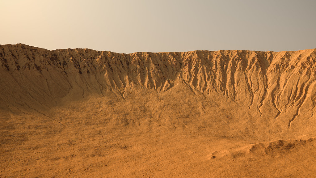
Immagine 1 – Ricostruzione del paesaggio di un cratere marziano interessato da gullies osservato dal suolo (le immagini satellitari osservano il fenomeno dall’alto). Crediti immagine: NASA/JPL-Caltech/UArizona.
Image 1 - Reconstruction of the landscape of a Martian crater affected by gullies observed from the ground (satellite images observe the phenomenon from above). Image credit: NASA/JPL-Caltech/UArizona.
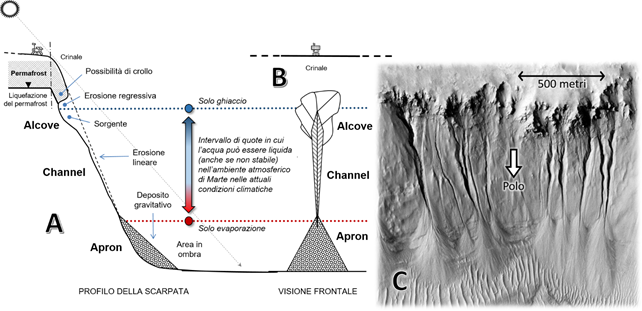
Immagine 2 - Negli schemi (A) e (B) vediamo rispettivamente il profilo e la visione frontale dei tre elementi morfologici che caratterizzano i "gullies" marziani (alcove, channel e apron) con l'indicazione del fenomeno erosivo o deposizionale prevalente. Gli orizzonti colorati delimitano il ristretto intervallo di quote in cui l'acqua può mantenersi liquida in superficie secondo il modello WSW. Al di sotto l'acqua può esistere solo come vapore e al di sopra solo come ghiaccio, che potrà al massimo sublimare (cioè passare direttamente da solido a vapore) qualora venisse esposto alla luce diretta del Sole. Secondo questo modello infatti l'acqua può sgorgare dalle sorgenti solo stagionalmente e per poche ore al giorno, solo mentre il versante è in ombra. Nell'immagine (C) un esempio reale è messo a confronto con lo schema (B). Immagine: "ESP_011727_1490" di HiRISE (NASA/JPL/Università dell'Arizona),
Image 2 - In diagrams (A) and (B) we see respectively the profile and the frontal view of the three morphological elements that characterize the Martian "gullies" (alcove, channel and apron) with the indication of the prevailing erosive or depositional phenomenon. The colored horizons delimit the narrow range of altitudes in which water can remain liquid on the surface according to the WSW model. Underneath, water can exist only as vapor and above only as ice, which can at most sublimate (that is, go directly from solid to vapor) if exposed to direct sunlight. According to this model, in fact, water can gush from the springs only seasonally and for a few hours a day, only while the slope is in the shade. In image (C) a real example is compared with the scheme (B). Image: "ESP_011727_1490" by HiRISE (NASA / JPL / University of Arizona),