Applicato un metodo innovativo per determinare la velocità di accumulo di energia per le faglie dell’Appennino centrale attraverso l’uso di dati geodetici e di stress.
Attraverso una innovativa analisi multidisciplinare, risultato delle osservazioni geodetiche di circa 20 anni e di un gran numero di dati aggiornati sulla direzione dello sforzo tettonico, è possibile quantificare la velocità del movimento delle faglie attive dell’Appennino centrale. Questo approccio potrebbe essere decisivo per determinare meglio la velocità del movimento delle faglie in un modo completamente innovativo e complementare alle classiche ed affidabili tecniche geologiche
È quanto è stato fatto nello studio “Partitioning the Ongoing Extension of the Central Apennines (Italy): Fault Slip Rates and Bulk Deformation Rates from Geodetic and Stress Data” pubblicato sulla rivista ‘Journal of Geophysical Research – Solid Earth’. La ricerca, che ha coinvolto competenze geodetiche, geologiche e modellistiche dell’Istituto Nazionale di Geofisica e Vulcanologia (INGV), è stata condotta in collaborazione con il Department of Earth, Planetary, and Space Sciences dell’University of California di Los Angeles (UCLA).
Come è noto, i terremoti sono generati da faglie, grandi piani in corrispondenza dei quali porzioni della crosta terrestre si muovono in tempi geologici l’una rispetto all’altra parallelamente al piano della faglia stessa. La velocità media su tempi geologici con cui questo processo avviene, chiamata slip rate nella letteratura scientifica, è un parametro cruciale perché quantifica il potenziale di ciascuna faglia all’interno dei modelli elaborati per valutare la pericolosità sismica di una data regione.
“Questo lavoro”, spiega Michele Carafa, autore della ricerca, “nasce durante la mia permanenza all’UCLA e si è sviluppato nell'ambito del “FIRB Abruzzo”, un importante progetto finanziato dal MIUR tra il 2011 e il 2016 e denominato ‘Indagini ad alta risoluzione per la stima della pericolosità̀ e del rischio sismico nelle aree colpite dal terremoto del 6 aprile 2009’. A mia memoria”, continua Carafa, “questa è la prima ricerca a livello europeo che mira esplicitamente a determinare lo slip rate di tutte le faglie attive presenti in un'importante area sismica, usando congiuntamente informazioni di diversa natura attualmente disponibili nel campo delle geoscienze, come i dati GPS e quelli che descrivono l’orientazione del campo dello sforzo in un materiale viscoelastico, quale è la crosta terreste. Esistono diverse tecniche per determinare lo slip rate di lungo termine: quella più semplice da spiegare si basa sul riconoscimento degli strati di roccia vecchi anche centinaia di migliaia di anni, posti ad altitudini differenti spesso anche centinaia di metri. Secondo una visione geologica classica, questi strati si trovavano inizialmente alla stessa quota, ed è ipotizzabile che l’attuale differenza topografica sia principalmente il risultato dei ripetuti terremoti avvenuti in tempi successivi lungo la faglia in esame, spesso determinabili con tecniche più o meno complesse. Ed è stato esattamente questo l’obiettivo del nostro gruppo di ricerca” prosegue Carafa, “avere dei primi dati per capire se, nell’arco degli ultimi 15-20 anni per i quali esistono misure geodetiche accurate, il comportamento del volume di roccia adiacente alla faglia sia compatibile con le stime disponibili di slip rate di lungo termine, ovvero quelle basate su metodi geologici. La risposta è stata sostanzialmente positiva: le stime di breve e lungo termine sono risultate congruenti fra loro. Questo risultato ci permetterà di capire e stimare meglio le forze responsabili dell’evoluzione tettonica degli Appennini e, quindi, in prospettiva di valutare con maggior accuratezza la pericolosità sismica della regione. Guardando indietro, posso dire che questa è stata veramente una bella sfida scientifica. Da un lato, i ricercatori esperti in geodesia del nostro team hanno raccolto tutte le informazioni necessarie per definire lo spostamento medio annuo di ciascuna delle stazioni GNSS distribuite nell’area di studio tra i vari accadimenti sismici, dall’altro, i ricercatori esperti in tettonica attiva hanno esaminato nel dettaglio la letteratura scientifica al fine di identificare le faglie comunemente accettate come attive. Infine, i modellisti hanno sintetizzato le informazioni ottenute dai due gruppi per giungere, utilizzando un metodo decisamente sofisticato, a calcolare lo slip rate medio di ciascuna faglia”.
“Per rafforzare il risultato abbiamo analizzato il dataset geodetico insieme a quello del campo dello sforzo attivo, disponibile nel database IPSI (Italian Present-day Stress Indicators), un altro prodotto sviluppato completamente dall’INGV”, prosegue il coordinatore della ricerca. “I risultati ottenuti, frutto delle nostre competenze, rappresentano solo un primo passo, e come tale possono essere affetti da incertezze che potranno essere superate continuando a lavorare in ciascuna delle tre aree in gioco: quella geodetica, quella geologica e quella modellistica”.
Se il primo step dello studio è frutto esclusivamente delle competenze dell’INGV, ben indirizzate dall’esperienza del collega Peter Bird della UCLA, gli sviluppi di questa ricerca, finalizzati ad una migliore comprensione dell’evoluzione geologica dell’area, vedranno le collaborazioni scientifiche con l’Università degli Studi dell’Aquila e con il Gran Sasso Science Institute (GSSI).
“Il metodo utilizzato per questa ricerca”, conclude il ricercatore, “è del tutto innovativo e richiede interazione con ulteriori competenze quali, ad esempio, quelle matematiche ed informatiche. C’è tanto da fare, ma integrare diverse competenze è stata una scelta vincente e ritengo sia sicuramente la strada da seguire per rendere questo tipo di ricerca utile per la collettività. Al riguardo, ci lusinga che la stessa Regione Abruzzo si sia mostrata da subito estremamente interessata a questa ricerca aggiungendo alla rete geodetica regionale - sotto la nostra supervisione scientifica – nuove stazioni GNSS collocate in siti strategici, proprio per poter migliorare il nostro modello”.
#ingv #appenninoCentrale #faglie
---
Investigating the large active faults of the central Apennines through an innovative multidisciplinary method
An innovative method allowed to determine the energy loading rate for the central Apennines faults by joint use of geodetic and stress data
Through an innovative multidisciplinary research, the result of 20 years of geodetic observations and a large number of updated data on the tectonic stress orientation, it is possible to quantify the slip rate of central Apennines active faults. This approach may be crucial for determining better fault slip rates in a completely innovative and complementary way relative to the classical and well-established geological techniques.
This approach is described in the paper “Partitioning the Ongoing Extension of the Central Apennines (Italy): Fault Slip Rates and Bulk Deformation Rates from Geodetic and Stress Data”, published in 'Journal of Geophysical Research - Solid Earth'. The research involved several working groups of the Istituto Nazionale di Geofisica e Vulcanologia (INGV), holding complementary expertise in geodesy, geology, and numerical modeling. The experiments were conducted in collaboration with the Department of Earth, Planetary, and Space Sciences of the University of California at Los Angeles (UCLA).
As known, earthquakes occur on faults, which can be described as surfaces along which the nearly-rigid viscous blocks of crust on either side have moved relative to one another parallel to the fracture over geologic times. The average slipping rate over geological times of this process, referred to as slip rate in the scientific literature, is a crucial parameter for quantifying the seismogenic potential of each fault, and hence to assess the seismic hazard of a given region.
"This work", explains Michele Carafa, author of the research, "was conceived when I was a visiting researcher at UCLA, and was later developed within ‘FIRB Abruzzo’ an important project funded by the Italian Ministry of Research between 2011 and 2016, entitled ‘High resolution analyses for the estimation of the seismic hazard and risk in the areas hit by the 6 April 2009 earthquake')". Carafa maintains that “this is the first article in Italy - if not in the broader Mediterranean region - that explicitly aimed to determine the slip rate of active faults crossing an important seismogenic area, based on the joint use of different kind of observations such as GPS measurements and data determining the stress orientations in the viscoelastic Earth crust. Different techniques have been used to determine the average long-term slip rate: the elementary technique is based on the recognition of rock layers that are hundreds of thousands of years old, placed at different altitudes, often even hundreds of meters. According to the classical geological method, these layers were once placed at the same altitude, and it is conceivable the present-day topographic offset is due to the past earthquakes, whose age can be determined in different ways”. Carafa goes on recalling that “This was exactly the goal of our research group: to have some initial data to understand if, over the past 15-20 years for which accurate geodetic measurements exist, the behavior of the rock volume adjacent to the fault is compatible with the available estimates of long-term slip rates, i.e. those based on geological methods. The first results confirm such agreement exists, as the short and long term estimates were consistently found to be compatible with each other. In perspective, this result allows us to understand better what are the forces responsible for the current tectonic evolution of the Apennines and to improve the assessment of the region’s seismic hazard. Looking back, I can say that our work was - and still is - an intriguing scientific challenge. On the one hand, geodesists of our group collected all the information necessary to define the secular annual displacement of each of the GNSS stations distributed in the study area, while on the other hand, the active tectonics researchers scrutinized the scientific literature to find out which faults are believed to be active. Finally, modelists synthesized all the information into a sophisticated method that determines the average slip rate of each fault".
The INGV scientist went on to explain that "To improve the overall compatibility with the geological settings of the region, we included the orientation of the principal stress axes available in the INGV database named ‘Italian Present-day Stress Indicators’, or IPSI". He also added that "The results we obtained, result of our skills, must necessarily be regarded as a first step: they are affected by uncertainties that may be reduced by replicating the experiment using the three scientific areas: geodesic, geological and modeling".
The published research is mainly the outcome of work conducted by INGV scientists, but it took advantage from the experience of Professor Emeritus Peter Bird of UCLA. Further developments will also entail a collaboration with the University of L'Aquila and with the Gran Sasso Science Institute (GSSI).
“Our research method”, concludes Carafa, “requires a highly varied expertise, and indeed we are willing to collaborate with mathematicians and HPC (High Performance Computing) experts. There is still a lot to do, but integrating different skills is the only possibility to move forward and to make this type of research useful for the community. In this regard, we were very pleased by the enthusiastic response of the Regione Abruzzo, whose officials - under our scientific supervision - promoted the extension of the regional GNSS network with four strategically located stations that will certainly improve our future results”.
#ingv #centralApennines #faults

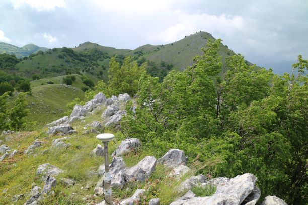
Foto - Una stazione GPS installata vicino a Bojano (CB) per studiare lo slip rate della faglia del Matese.
Photo - Temporary GPS station installed in the proximity of Bojano for investigating the slip-rate of the Matese fault.

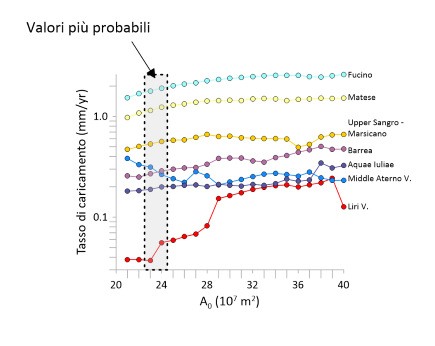
Figura 1 - Slip rate stimato tramite dati relativi agli ultimi 15-20 anni per le principali faglie dell’Appenino centrale.
Figure 1 – Preferred slip rate values obtained for the main active faults of the central Apennines using 15-20 years of GPS measurements.

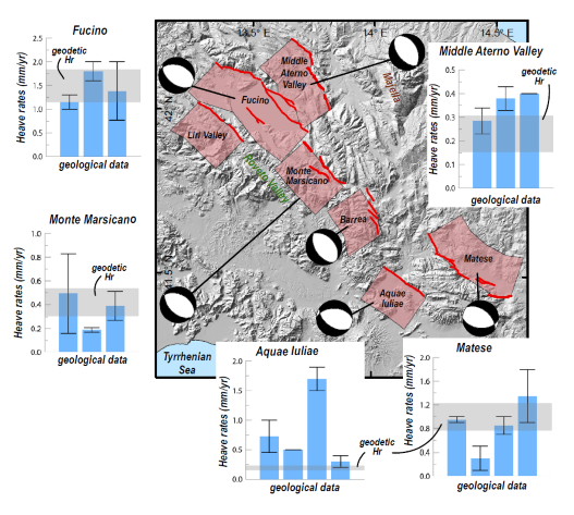
Figura 2 - Appennino centrale: confronto fra tassi di caricamento (slip rates) delle principali faglie attive ottenuti con dati GPS (barre orizzontali di color grigio) e ottenuti come rateo di scorrimento relativo dei blocchi crostali sui lati di ciascuna faglia dagli studi geologici disponibili in letteratura (tre o quattro a seconda dei casi: barre blu).
Figure 2 - Central Apennines: comparison between geodetic slip rates (gray stripes) and the corresponding geological estimates available in the literature (three or four, depending on cases: blue bars) for the main active faults of the central Apennines.


