


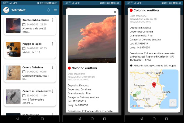
 Figura: Esempi di schermate visualizzabili sull'App TefraNet dell'INGV --- Figure: Examples of screens that can be viewed on the INGV TefraNet App
Una nuova App per dispositivi iOSe Android consente ai cittadini residenti nelle aree vulcaniche attive di segnalare in real-time la ricaduta a terra di ceneri e lapilli durante le eruzioni
TefraNet è la nuova App che l’Istituto Nazionale diGeofisica e Vulcanologia (INGV) ha sviluppato nell’ambito del monitoraggio vulcanico. Adatta ai device portatili maggiormente in uso (smarthphone e tablet), TefraNet vuole coinvolgere attivamente i cittadini delle aree esposte al rischio di caduta di tefra, ovvero ceneri, lapilli e bombe prodotti dalle attività esplosive più intense, attraverso la raccolta di informazioni in tempo reale.
TefraNet, che conta già centinaia di utenti registrati, ha conosciuto un importante banco di prova nel corso dell’attuale crisi eruttiva dell’Etna caratterizzata da una sequenza di fontane di lava, fornendo ottimi risultati in termini di risposta del pubblico con segnalazioni inviate da cittadini residenti anche in aree piuttosto distanti dal vulcano. Ciò ha permesso ai ricercatori dell’INGV di osservare in real-time la ricaduta di tefra nelle diverse zone siciliane interessate, nonché di avere una visione della colonna eruttiva da varie angolazioni, dati a loro volta utili a studiare in tempo reale l’eruzione in corso.
L’App nasce nell’ambito del Progetto premiale “Ash-RESILIENCE – A research infrastructure for volcanic ash hazard assessment to aviation and communities living near Italian active volcanoes”, finanziato nel 2015 dal MIUR e volto a realizzare strumenti in grado di mitigare gli effetti della caduta dei prodotti dell’attività vulcanica esplosiva nelle due principali aree metropolitane italiane con vulcani attivi all’interno del loro territorio, ovvero Catania e Napoli.
Dal 1998 l’Etna è stato interessato da oltre 200 eventi parossistici, caratterizzati da forte attività stromboliana e fontane di lava dai crateri sommitali, che hanno generato colonne eruttive alte fino a 10 km sopra il vulcano seguite da cadute di tefra nelle aree circostanti.
L’emissione di ceneri in atmosfera e la loro dispersione al suolo hanno importanti implicazioni anche in materia di protezione civile: la sorveglianza costante del vulcano e lo studio dei suoi depositi risultano, infatti, fondamentali per lo sviluppo e la validazione di modelli di simulazione della propagazione dei tefra in atmosfera e la loro successiva ricaduta a terra, con l’obiettivo di mitigare quanto più possibile i rischi per le popolazioni residenti nelle località maggiormente esposte.
Le aree metropolitane di Catania e Napoli sono densamente popolate. In esse, infatti, si registrano, rispettivamente, quasi un milione di abitanti e oltre tre milioni di abitanti. Persone che, per lo più, vivono alle pendici dell’Etna, del Vesuvio e nei Campi Flegrei. Inoltre, all’interno dei loro territori ospitano due scali aeroportuali molto trafficati, quello di Catania Fontanarossa e di Napoli Capodichino, considerando, oltretutto, che sul territorio catanese ha sede la base militare di Sigonella, noto presidio NATO. In zone con queste caratteristiche, dunque, l’emissione di prodotti piroclastici in atmosfera e la loro ricaduta a terra possono aumentare notevolmente i rischi legati alla viabilità nonché alle ordinarie operazioni aeroportuali.
Per ridurre e ‘controllare’ questi rischi, grazie all’App TefraNet i cittadini possono ora partecipare al monitoraggio in real-time dell’Etna, segnalando e condividendo in tempo reale – durante l’eruzione – importanti informazioni sulla ricaduta al suolo di ceneri, lapilli e bombe vulcaniche. I dati, tra cui immagini geo-referenziate, osservazioni e localizzazioni GPS, vengono archiviati in un geodatabase all’interno dell’App e possono essere visualizzati ‘navigando’ tra le segnalazioni attraverso una ricerca per data o per evento.
Il prossimo obiettivo, oltre all’implementazione dell’App per il monitoraggio dell’area partenopea, sarà quello di creare una versione di TefraNet in inglese. In futuro, infatti, l’App potrà essere adattata anche a vulcani presenti in altre regioni d’Italia e del mondo dove la dispersione di cenere in atmosfera rappresenta un problema per la vita di tutti giorni, fornendo così informazioni utili alle popolazioni residenti sulla caduta di tefra al suolo.
Per eventuali suggerimenti e feedback sull’App è possibile inviare una mail all’indirizzoQuesto indirizzo email è protetto dagli spambots. È necessario abilitare JavaScript per vederlo. .
---
TefraNet, INGV launches an App for real-time monitoring of volcanic ash emissions
A new App for iOS and Android devices allows citizens residing in active volcanic areas to report in real-time the ash fallout during eruptions
TefraNet is the new App that the Istituto Nazionale di Geofisica e Vulcanologia (INGV) has developed in the field of volcanic monitoring. Suitable for the most commonly used portable devices (smartphones and tablets), TefraNet seeks to actively involve the citizens of the areas exposed to the risk of tephra fallout, i.e. ash, lapilli and bombs produced by the most intense explosive activities, by collecting information in real time.
TefraNet, which already has hundreds of registered users, has been put to the test during the current eruptive crisis of Etna characterized by a sequence of lava fountains. It has provided excellent results in terms of public response with reports sent by citizens also residing in fairly distant areas from the volcano. This allowed INGV researchers to observe the tephra fallout in real-time in the various Sicilian areas concerned, as well as to have a view of the eruptive column from various points, in order to study the ongoing eruption in real-time.
The App was developed as part of the Project “Ash-RESILIENCE - A research infrastructure for volcanic ash hazard assessment to aviation and communities living near Italian active volcanoes”, funded in 2015 by MIUR. The project aimed at creating tools capable of mitigating the effects of the fall of explosive volcanic activity’s products in the two Italian metropolitan areas with active volcanoes within their territory, Catania and Naples.
Since 1998, Etna has been affected by more than 200 paroxysmal events, characterized by strong Strombolian activity and lava fountains from the summit craters, which generated eruptive columns up to 10 km high above the volcano, followed by tephra falls in the surrounding areas.
The injection of ash into the atmosphere and its dispersal on the ground also have important implications for civil protection reasons: the constant surveillance of the volcano and the study of its tephra deposits are, in fact, fundamental for the development and validation of numerical models. These models simulate the propagation of tephra in the atmosphere and their subsequent fallout on the ground, with the aim of mitigating the risks for those living in the most exposed locations as much as possible.
The metropolitan areas of Catania and Naples are densely inhabited, with populations of almost one million and over three million, respectively, the people living mainly on the slopes of Etna, Vesuvius and in the Campi Flegrei. In addition, these territories have two very busy airports, namely Catania Fontanarossa and Naples Capodichino, while the NATO military base of Sigonella is located in the Catania area too. In areas with these characteristics, the emission of pyroclastic products into the atmosphere and their fallout on the ground can therefore significantly increase the risks associated with traffic and ordinary airport operations.
To mitigate and 'control' these risks, thanks to the TefraNet App, citizens can now participate in real-time monitoring of Etna, reporting and sharing - during the eruption - important information on the ash fallout on the ground. The acquired data, including geo-referenced images, observations and GPS locations, are stored in a geodatabase within the App and can be viewed by 'browsing' the reports through a search by date or by event.
The next goal, in addition to implementing the App for monitoring the Neapolitan area, will be to create a version of TefraNet in English. In the future, the App can also be adapted to volcanoes in other regions of Italy and around the world where the dispersal of ash into the atmosphere represents a problem for everyday life, thus providing useful information to the resident populations on tephra falls on the ground.
For any suggestions and feedback on the App, you can send an email toQuesto indirizzo email è protetto dagli spambots. È necessario abilitare JavaScript per vederlo. .
TefraNet è la nuova App che l’Istituto Nazionale diGeofisica e Vulcanologia (INGV) ha sviluppato nell’ambito del monitoraggio vulcanico. Adatta ai device portatili maggiormente in uso (smarthphone e tablet), TefraNet vuole coinvolgere attivamente i cittadini delle aree esposte al rischio di caduta di tefra, ovvero ceneri, lapilli e bombe prodotti dalle attività esplosive più intense, attraverso la raccolta di informazioni in tempo reale.
TefraNet, che conta già centinaia di utenti registrati, ha conosciuto un importante banco di prova nel corso dell’attuale crisi eruttiva dell’Etna caratterizzata da una sequenza di fontane di lava, fornendo ottimi risultati in termini di risposta del pubblico con segnalazioni inviate da cittadini residenti anche in aree piuttosto distanti dal vulcano. Ciò ha permesso ai ricercatori dell’INGV di osservare in real-time la ricaduta di tefra nelle diverse zone siciliane interessate, nonché di avere una visione della colonna eruttiva da varie angolazioni, dati a loro volta utili a studiare in tempo reale l’eruzione in corso.
L’App nasce nell’ambito del Progetto premiale “Ash-RESILIENCE – A research infrastructure for volcanic ash hazard assessment to aviation and communities living near Italian active volcanoes”, finanziato nel 2015 dal MIUR e volto a realizzare strumenti in grado di mitigare gli effetti della caduta dei prodotti dell’attività vulcanica esplosiva nelle due principali aree metropolitane italiane con vulcani attivi all’interno del loro territorio, ovvero Catania e Napoli.
Dal 1998 l’Etna è stato interessato da oltre 200 eventi parossistici, caratterizzati da forte attività stromboliana e fontane di lava dai crateri sommitali, che hanno generato colonne eruttive alte fino a 10 km sopra il vulcano seguite da cadute di tefra nelle aree circostanti.
L’emissione di ceneri in atmosfera e la loro dispersione al suolo hanno importanti implicazioni anche in materia di protezione civile: la sorveglianza costante del vulcano e lo studio dei suoi depositi risultano, infatti, fondamentali per lo sviluppo e la validazione di modelli di simulazione della propagazione dei tefra in atmosfera e la loro successiva ricaduta a terra, con l’obiettivo di mitigare quanto più possibile i rischi per le popolazioni residenti nelle località maggiormente esposte.
Le aree metropolitane di Catania e Napoli sono densamente popolate. In esse, infatti, si registrano, rispettivamente, quasi un milione di abitanti e oltre tre milioni di abitanti. Persone che, per lo più, vivono alle pendici dell’Etna, del Vesuvio e nei Campi Flegrei. Inoltre, all’interno dei loro territori ospitano due scali aeroportuali molto trafficati, quello di Catania Fontanarossa e di Napoli Capodichino, considerando, oltretutto, che sul territorio catanese ha sede la base militare di Sigonella, noto presidio NATO. In zone con queste caratteristiche, dunque, l’emissione di prodotti piroclastici in atmosfera e la loro ricaduta a terra possono aumentare notevolmente i rischi legati alla viabilità nonché alle ordinarie operazioni aeroportuali.
Per ridurre e ‘controllare’ questi rischi, grazie all’App TefraNet i cittadini possono ora partecipare al monitoraggio in real-time dell’Etna, segnalando e condividendo in tempo reale – durante l’eruzione – importanti informazioni sulla ricaduta al suolo di ceneri, lapilli e bombe vulcaniche. I dati, tra cui immagini geo-referenziate, osservazioni e localizzazioni GPS, vengono archiviati in un geodatabase all’interno dell’App e possono essere visualizzati ‘navigando’ tra le segnalazioni attraverso una ricerca per data o per evento.
Il prossimo obiettivo, oltre all’implementazione dell’App per il monitoraggio dell’area partenopea, sarà quello di creare una versione di TefraNet in inglese. In futuro, infatti, l’App potrà essere adattata anche a vulcani presenti in altre regioni d’Italia e del mondo dove la dispersione di cenere in atmosfera rappresenta un problema per la vita di tutti giorni, fornendo così informazioni utili alle popolazioni residenti sulla caduta di tefra al suolo.
Per eventuali suggerimenti e feedback sull’App è possibile inviare una mail all’indirizzo
---
TefraNet, INGV launches an App for real-time monitoring of volcanic ash emissions
A new App for iOS and Android devices allows citizens residing in active volcanic areas to report in real-time the ash fallout during eruptions
TefraNet is the new App that the Istituto Nazionale di Geofisica e Vulcanologia (INGV) has developed in the field of volcanic monitoring. Suitable for the most commonly used portable devices (smartphones and tablets), TefraNet seeks to actively involve the citizens of the areas exposed to the risk of tephra fallout, i.e. ash, lapilli and bombs produced by the most intense explosive activities, by collecting information in real time.
TefraNet, which already has hundreds of registered users, has been put to the test during the current eruptive crisis of Etna characterized by a sequence of lava fountains. It has provided excellent results in terms of public response with reports sent by citizens also residing in fairly distant areas from the volcano. This allowed INGV researchers to observe the tephra fallout in real-time in the various Sicilian areas concerned, as well as to have a view of the eruptive column from various points, in order to study the ongoing eruption in real-time.
The App was developed as part of the Project “Ash-RESILIENCE - A research infrastructure for volcanic ash hazard assessment to aviation and communities living near Italian active volcanoes”, funded in 2015 by MIUR. The project aimed at creating tools capable of mitigating the effects of the fall of explosive volcanic activity’s products in the two Italian metropolitan areas with active volcanoes within their territory, Catania and Naples.
Since 1998, Etna has been affected by more than 200 paroxysmal events, characterized by strong Strombolian activity and lava fountains from the summit craters, which generated eruptive columns up to 10 km high above the volcano, followed by tephra falls in the surrounding areas.
The injection of ash into the atmosphere and its dispersal on the ground also have important implications for civil protection reasons: the constant surveillance of the volcano and the study of its tephra deposits are, in fact, fundamental for the development and validation of numerical models. These models simulate the propagation of tephra in the atmosphere and their subsequent fallout on the ground, with the aim of mitigating the risks for those living in the most exposed locations as much as possible.
The metropolitan areas of Catania and Naples are densely inhabited, with populations of almost one million and over three million, respectively, the people living mainly on the slopes of Etna, Vesuvius and in the Campi Flegrei. In addition, these territories have two very busy airports, namely Catania Fontanarossa and Naples Capodichino, while the NATO military base of Sigonella is located in the Catania area too. In areas with these characteristics, the emission of pyroclastic products into the atmosphere and their fallout on the ground can therefore significantly increase the risks associated with traffic and ordinary airport operations.
To mitigate and 'control' these risks, thanks to the TefraNet App, citizens can now participate in real-time monitoring of Etna, reporting and sharing - during the eruption - important information on the ash fallout on the ground. The acquired data, including geo-referenced images, observations and GPS locations, are stored in a geodatabase within the App and can be viewed by 'browsing' the reports through a search by date or by event.
The next goal, in addition to implementing the App for monitoring the Neapolitan area, will be to create a version of TefraNet in English. In the future, the App can also be adapted to volcanoes in other regions of Italy and around the world where the dispersal of ash into the atmosphere represents a problem for everyday life, thus providing useful information to the resident populations on tephra falls on the ground.
For any suggestions and feedback on the App, you can send an email to