

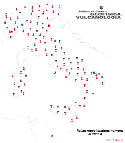
The image shows a detailed map of the positions of these stations in Italy. For each station a monograph has been created which describes the site, how to reach it, the ground references, the azimuths and all the information useful for a more complete description of the station itself has been reported.
The measurement campaigns carried out as part of the activities of the national magnetic grid allow the values of the earth's magnetic field and their temporal variation to be realised, on a map. Currently, the Italian Magnetic Network consists of 120 stations, called cornerstones, distributed as uniformly as possible throughout the country. At each of these stations, measurements of the elements of the magnetic field are carried out, on average every 5 years.
The magnetic data collected during the measurement campaigns at the strongholds of the national magnetic network, suitably processed, allow the creation of a cartography in which the values of the magnetic field and the relative temporal variations are shown on a map. These maps are produced with a five-year deadline.
The latest magnetic card for Italy (related to the year 2015.0) was created as part of the collaboration between the National Institute of Geophysics and Volcanology (INGV) and the Italian Military Geographic Institute (IGM). Compiled in four sheets on the basis of magnetic measurements, it describes the values of the magnetic elements D, H, Z and the intensity F for Italy, on a scale of 1:2000000.
This card is available in both paper and electronic formats.
Cartography at 2015.0